
查看原文全部插图(15 幅)






内容提要
古老的邦纳维尔湖在冰期(ice age)曾覆盖美国西部大片区域,其干涸后留下的盐滩和地貌不仅是地质研究的宝库,也成为人类探索与工程创新的舞台。美国国家航天局(NASA)利用此地模拟金星(Venus)环境,测试用于探测金星大气的仪器设备。
原文全文译文
在鼎盛时期,古老的邦纳维尔湖(Lake Bonneville)曾是一番壮丽的景象。这座冰期(ice age)湖泊的面积几乎与密歇根湖相当,横跨犹他州西部以及内华达州和爱达荷州的部分地区。当它最终退去时,留下了平坦、明亮的盐滩和富含矿物质的干湖床——这片景观后来成为了工程壮举、技术创新以及探索与绝望史诗故事的背景。
At its peak, ancient Lake Bonneville would have been a sight to behold. Nearly as large as Lake Michigan, the Ice Age lake spread across much of western Utah and parts of Nevada and Idaho. When it eventually receded, it left behind flat, bright playas and salt flats rich with minerals—a landscape that would later serve as the setting for feats of engineering and technological ingenuity, as well as epic tales of exploration and desperation.
邦纳维尔湖形成于约55000年前的一个凉爽潮湿时期,当时现今爱达荷州东南部的火山喷发改变了贝尔河(Bear River)的流向,导致水流汇集在宝石谷(Gem Valley)及南部的其他盆地中。数万年来,红岩山口(Red Rock Pass)的一道天然大坝帮助限制了湖水的范围。
Lake Bonneville began forming about 55,000 years ago during a cool, wet period, when volcanic eruptions in what's now southeastern Idaho diverted the Bear River, causing water to gather in Gem Valley and other basins to the south. For tens of thousands of years, a natural dam at Red Rock Pass helped confine the lake.
随后,大约在18000年前,湖水冲破了大坝,引发了一场涌入哥伦比亚河(Columbia River)系统的洪流。在为期六周的时间里,作为北美最大的洪水之一,湖泊水位下降了超过350英尺(105米)。随着随后几千年气候变暖和干燥,湖泊急剧萎缩,留下了包括今日大盐湖(Great Salt Lake)、犹他湖(Utah Lake)和塞维尔湖(Sevier Lake)在内的残迹。
Then, about 18,000 years ago, water breached that dam, unleashing a torrent that entered the Columbia River system. Over a six-week period, amid one of North America's largest floods, lake levels plummeted by more than 350 feet (105 meters). As the climate warmed and dried in subsequent millennia, the lake shrank dramatically, leaving remnants that include today's Great Salt Lake, Utah Lake, and Sevier Lake.
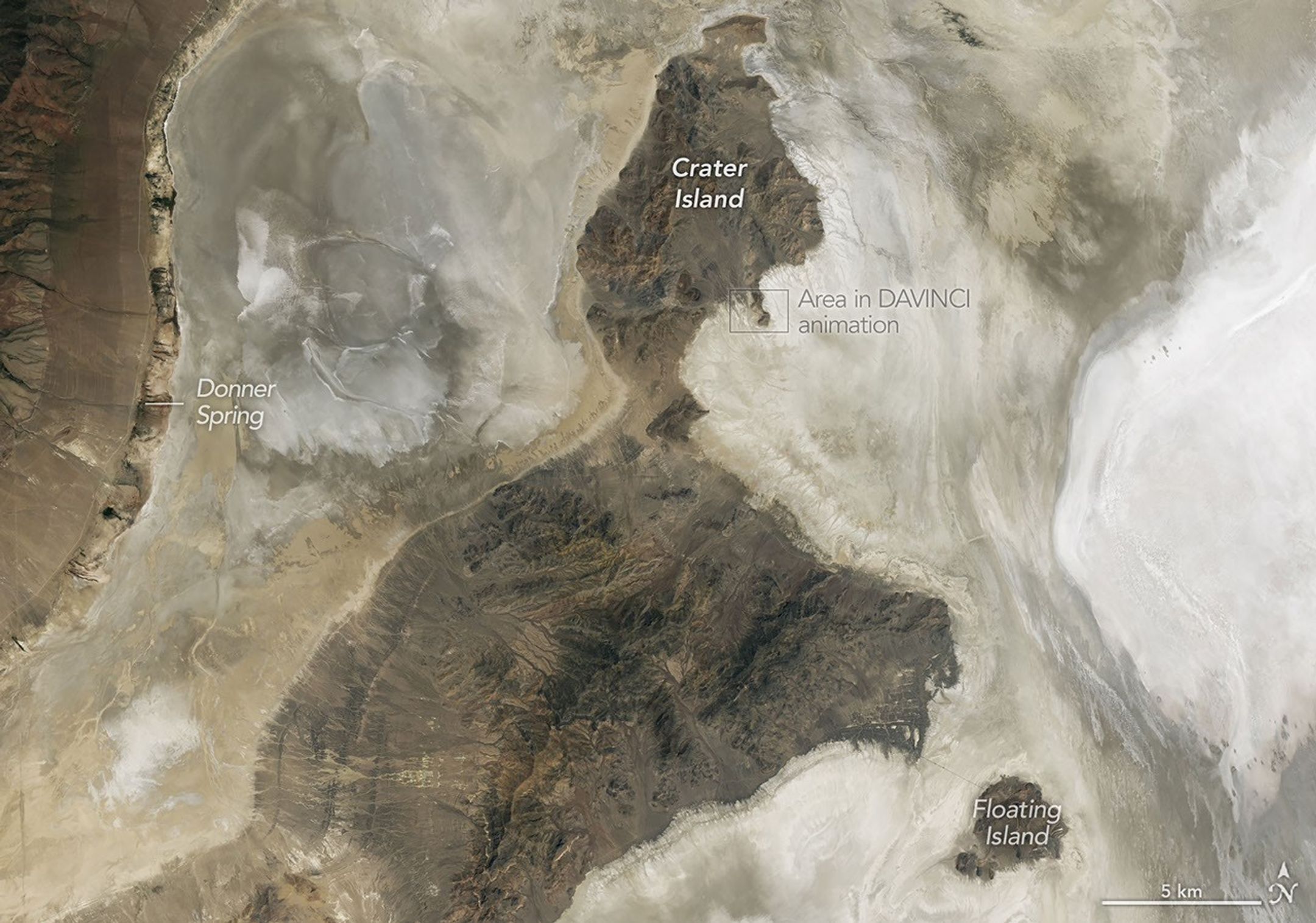
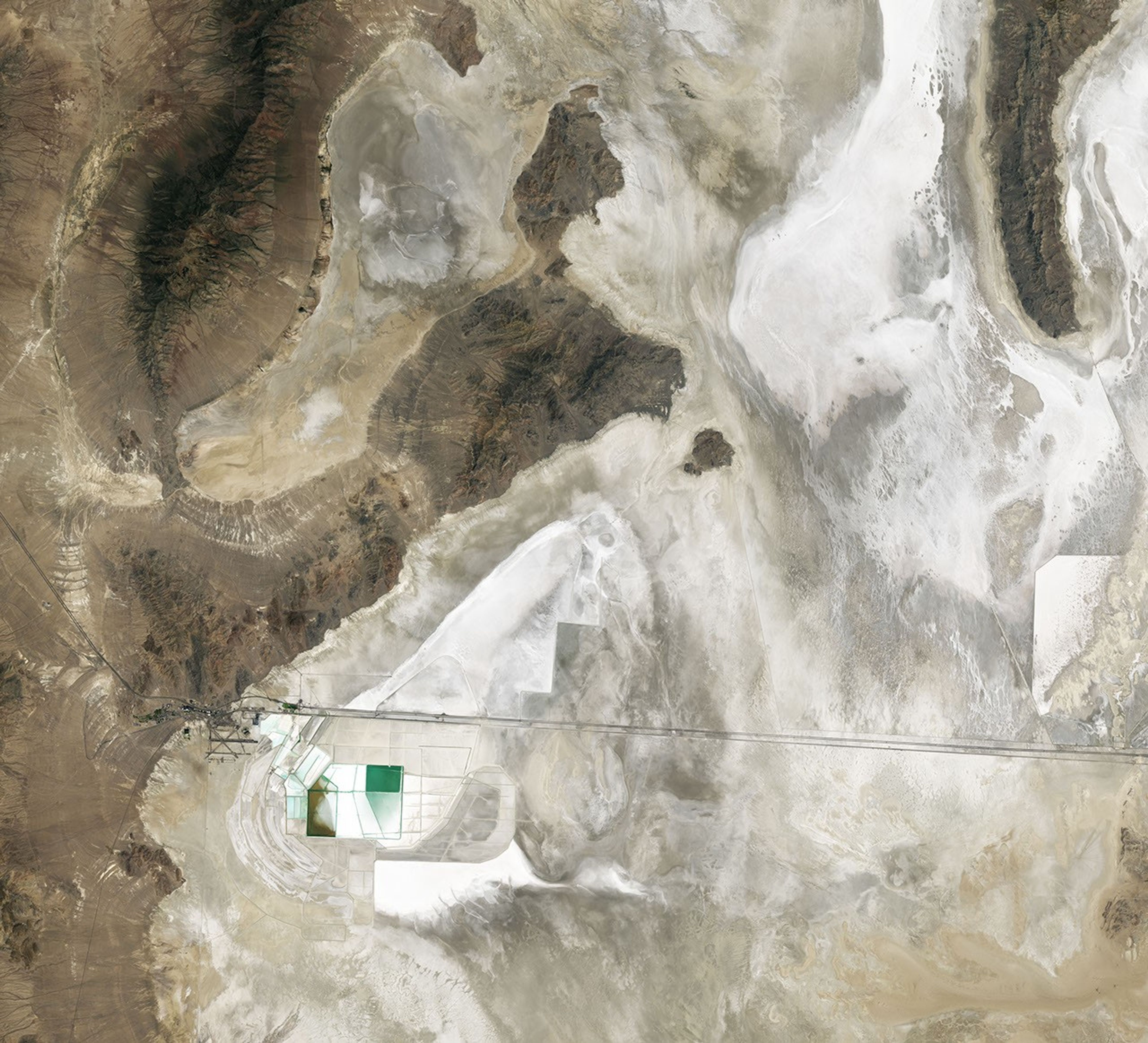
邦纳维尔湖可能已经消失,但它对该地区地貌留下的印记依然存在——即使在卫星(satellite)图像中也是如此。在这张由美国国家航天局(NASA)-美国地质调查局(USGS)Landsat 8卫星上的陆地成像仪(OLI)拍摄的图像(见下文)中,浴缸状的环带和波浪切割的阶地勾勒出了昔日湖岸线的位置。干涸的湖床——细粒粘土、泥灰岩和沙质沉积物在此沉淀——与周围更暗、更多岩石且植被更茂密的区域相比显得苍白。
Lake Bonneville may be gone, but its imprint on the region's landscape remains—even in satellite imagery. In this image (below) captured by the OLI (Operational Land Imager) on the NASA-USGS Landsat 8 satellite, bathtub-like rings and wave-cut terraces trace the position of former shorelines. The dried lakebed—where fine-grained clay, marl, and sandy sediment settled out of the water—appears pale in comparison to the darker, rockier, more vegetated surroundings.
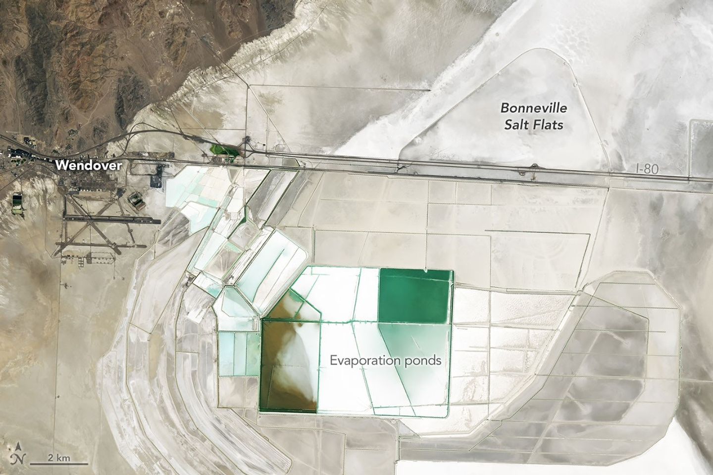
在盆地的深处,径流和地下水依然汇集的地方,明亮的蒸发岩矿物沉积物覆盖了地表,形成了盐滩。这些极其平坦的地表是水分逐渐蒸发并浓缩矿物质,从而产生卤水和坚硬矿物结壳的产物,通常包括石盐和石膏,以及含钾和镁的盐类。这些卤水和沉积物——特别是用作肥料的钾肥——长期以来使该盐滩成为采矿的目标,如上方和下方的矩形蒸发池所示。
In deep parts of the basin, where runoff and groundwater still pool, bright deposits of evaporite minerals coat the land surfaces, forming salt flats. These remarkably flat surfaces are the product of water gradually evaporating and concentrating minerals to produce brines and hard mineral crusts, typically including halite and gypsum, along with potassium- and magnesium-bearing salts. Brines and deposits like these—particularly of potash, which is used as a fertilizer—have long made the playa a target for mining, as seen in the rectangular evaporation ponds above and below.
相比之下,在盐滩上方隆起的更黑暗、更崎岖的地形——包括银岛山脉(Silver Island Mountains)、纽芬兰山脉(Newfoundland Mountains)和飞行员山脉(Pilot Range)——是由数亿年前抗侵蚀的沉积岩和变质沉积岩(metasedimentary bedrock)层构成的。这些山脉还包含较年轻的火成岩(igneous rock)和变质岩(metamorphic rock),它们是在岩浆侵入古老的沉积序列时形成的。
In contrast, the darker, more rugged terrain—including the Silver Island Mountains, the Newfoundland Mountains, and the Pilot Range—that rises above the playas is built from layers of erosion-resistant sedimentary and metasedimentary bedrock that is hundreds of millions of years old. These mountains also contain younger igneous and metamorphic rocks that formed when magma intruded into the ancient sedimentary sequence.
例如,巨爵座(Crater)岛由沉积岩组成,包括在浅海中沙子堆积形成的富含二氧化硅的砂岩和石英岩,以及石英二长岩、花岗岩和其他火成岩的侵入体。地壳拉伸时期后来产生了定义了该景观的断块山脉。
Crater Island, for instance, is composed of sedimentary rocks, including silica-rich sandstones and quartzites that formed as sands accumulated in a shallow ocean, as well as intrusions of quartz monzonite, granites, and other igneous rocks. Periods of crustal stretching later produced the fault-block mountains that define the landscape.
2026年6月,当美国国家航天局(NASA)的科学家和工程师与该机构的DAVINCI任务组合作来到巨爵座岛——他们称之为“地球上的金星(Venus on Earth)”——进行实地测试时,绘制此类地质差异图成为了焦点。他们测试了一套相机和仪器包的设计,这些设备最终将穿过金星浓厚的大气层,并以比这些Landsat图像更精细的比例拍摄山脉。在60分钟的下降过程中,这个开创性的探测器将捕捉近红外(near-infrared)图像,测量大气化学成分,并以前所未有的细节探索这个世界的环境。
Mapping geological distinctions like this took center stage in June 2026 when NASA scientists and engineers working with the agency's DAVINCI mission came to Crater Island—a place they call "Venus on Earth"—to field-test the design of a set of cameras and a package of instruments that will eventually descend through the thick atmosphere of Venus and photograph mountains at scales finer than these Landsat images. During a 60-minute descent, the pioneering probe will capture near-infrared images, measure the atmospheric chemistry, and explore the environment of a world in unprecedented detail.
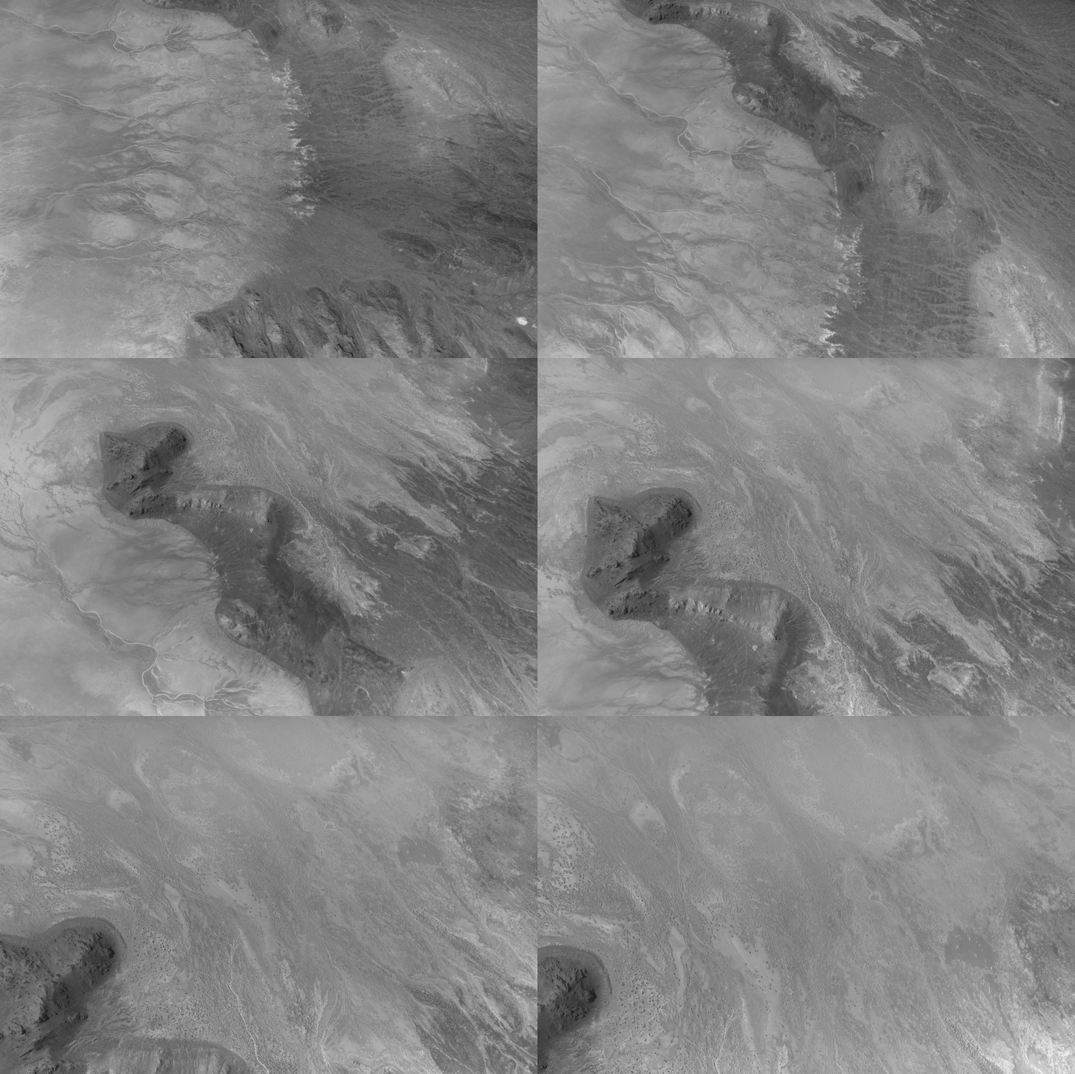
在巨爵座岛的排练期间,相机系统在悬挂于直升机下方并向地表下降的过程中,拍摄了数百张各种岩层的图像,包括富含铁和富含二氧化硅的岩石单元。仅使用DAVINCI相机系统获取的图像,团队就制作了与现有地质图一致的该区域三维地图,这使科学家们确信,他们将能够绘制出DAVINCI将要研究的位于金星上的类似山区——一个被称为阿尔法区(Alpha Regio)的区域——的地质图。
During the rehearsals at Crater Island, the camera system took hundreds of images of various rock formations, including iron-rich and silica-rich rock units, while suspended from a helicopter as it descended toward the surface. Using only the images acquired by DAVINCI's camera systems, the team made three-dimensional maps of the area consistent with existing geologic maps, giving the scientists confidence that they will be able to map the geology of an analogous mountainous region on Venus that DAVINCI will study, an area called Alpha Regio.
其他史诗般的冒险也曾在邦纳维尔湖的盐滩上及其周围上演。平坦、光滑的地表经常成为创造新陆地速度纪录的背景。1960年,米基·汤普森(Mickey Thompson)成为第一位突破时速400英里(640公里)大关的美国人,他在邦纳维尔盐滩上驾驶一辆流线型赛车达到了时速406.60英里(654.36公里)。这一壮举使他暂时赢得了“地球上最快的人”的绰号。
Other epic adventures have played out on and around Lake Bonneville's playas, as well. The flat, smooth surfaces have often been the setting for new land speed records. In 1960, Mickey Thompson became the first American to break the 400-miles-per-hour (640 kilometers-per-hour) barrier, hitting 406.60 miles per hour (654.36 kilometers per hour) in a streamlined race car on the Bonneville Salt Flats. The feat temporarily earned him the nickname "fastest man on Earth."
最近,在2026年8月,第一位在陆地上突破音障的人安迪·格林(Andy Green)创下了氢燃料内燃机车的最快陆地速度纪录,达到了时速406.320英里(653.909公里)。通过燃烧氢气而非汽油,这辆“火箭车”没有产生二氧化碳(carbon dioxide)。
More recently, in August 2026, Andy Green, the first person to break the sound barrier on land, set a record for the fastest land speed in a hydrogen-fueled internal-combustion vehicle, reaching 406.320 miles per hour (653.909 kilometers per hour). By burning hydrogen rather than gasoline, the "rocket car" produced no carbon dioxide.
近两个世纪前,即1846年8月,命运多舛的唐纳-里德(Donner-Reed)探险队成员也经过了巨爵座岛的南缘。作为通往飞行员峰(Pilot Peak)捷径的一部分,他们从黑斯廷斯山口(Hastings Pass)出发,经过浮岛(Floating Island),向唐纳泉(Donner Spring)进发。然而,作为一个不祥的预兆,他们沉重的马车压破了薄薄的盐壳,陷入了下方的泥泞中,这减慢了他们的速度,并促使他们在沙漠中遗弃了几辆马车。
Nearly two centuries earlier, in August 1846, members of the ill-fated Donner-Reed Party also passed along the southern edge of Crater Island. As part of a shortcut toward Pilot Peak, they journeyed from Hastings Pass, past Floating Island, and toward Donner Spring. However, in an ominous sign of challenges to come, their heavy wagons broke through the thin salt crust and became mired in underlying mud, slowing them down and prompting them to abandon several wagons in the desert.
图注:美国国家航天局(NASA)地球天文台(Observatory)图像由Michala Garrison制作,使用了美国地质调查局(U.S. Geological Survey)的Landsat数据。故事由Adam Voiland撰写。
NASA Earth Observatory images by Michala Garrison, using Landsat data from the U.S. Geological Survey. Story by Adam Voiland.
参考文献与资源
References & Resources
- 土地利用解释中心,Intrepid Potash Wendover。访问日期:2026年8月21日。
- The Center for Land Use Interpretation, Intrepid Potash Wendover. Accessed August 21, 2026.
- Garvin, J.B., et al. (2022) Revealing the Mysteries of Venus: The DAVINCI Mission. 行星科学学报(Planetary Science Journal), 3(117)。
- Garvin, J.B., et al. (2022) Revealing the Mysteries of Venus: The DAVINCI Mission. The Planetary Science Journal, 3(117).
- 希尔空军基地(2026年1月28日)Traces of Travel: Donner-Reed Wagon Sites on the Hastings Cutoff。访问日期:2026年8月21日。
- Hill Air Force Base (2026, January 28) Traces of Travel: Donner-Reed Wagon Sites on the Hastings Cutoff. Accessed August 21, 2026.
- 爱达荷州立大学,邦纳维尔湖洪水。访问日期:2026年8月21日。
- Idaho State University, Lake Bonneville Flood. Accessed August 21, 2026.
- 美国国家航天局(NASA)(2026年7月14日)犹他州直升机飞行测试NASA的DAVINCI任务前往金星(Venus)。访问日期:2026年8月21日。
- NASA (2026, July 14) Utah Helicopter Flights Test NASA’s DAVINCI Mission to Venus. Accessed August 21, 2026.
- NASA,DAVINCI。访问日期:2026年8月21日。
- NASA, DAVINCI. Accessed August 21, 2026.
- NASA地球天文台(Earth Observatory)(2018年2月25日)邦纳维尔盐滩。访问日期:2026年8月21日。
- NASA Earth Observatory (2018, February 25) Bonneville Salt Flats. Accessed August 21, 2026.
- 美国国家公园管理局,唐纳和里德马车队事件。访问日期:2026年8月21日。
- National Park Service, Donner and Reed Wagon Train Incident. Accessed August 21, 2026.
- 犹他州地质调查局,邦纳维尔湖。访问日期:2026年8月21日。
- Utah Geological Survey, Lake Bonneville. Accessed August 21, 2026
- 犹他州地质调查局,地质历史。访问日期:2026年8月21日。
- Utah Geological Survey, Geologic History. Accessed August 21, 2026.
- 犹他州地质调查局,大盐湖与邦纳维尔湖。访问日期:2026年8月21日。
- Utah Geological Survey, Great Salt Lake and Lake Bonneville. Accessed August 21, 2026.
- 犹他州自然资源部(1990)卢辛4西南四分之一图幅地质图。访问日期:2026年8月21日。
- Utah Department of Natural Resources (1990) Geologic Map of the Lucin 4 SW Quadrangle. Accessed August 21, 2026.
来源与许可
原文来自公共领域来源;译文由机器生成,请以原文为准。 原始页面