
查看原文全部插图(12 幅)







内容提要
2026年夏季,一座巨大的冰山出现在丹麦海峡,距离其格陵兰岛东北部的起源地已漂流超过一千公里。科学家通过Landsat 9卫星影像分析了该冰山的特征,并推测其可能源自Zachariæ Isstrøm冰川附近的残余冰架。
原文全文译文
格陵兰岛崎岖的海岸线上布满了峡湾,其中许多峡湾孕育着海洋终止冰川,这些冰川会定期崩解出冰山并落入水中。每年夏天,当海冰消融后,在岛上的峡湾中看到这些大小不一的冰山漂流是很常见的现象。2026年夏季,一座异常巨大的冰山出现在丹麦海峡,距离其明显的起源地向南超过一千公里。
Greenland’s jagged coastline is lined with fjords, many of them cradling marine-terminating glaciers that routinely calve icebergs into the water. It’s common to see these bergs, small and large, drifting in the island’s fjords each summer once the sea ice breaks up. In summer 2026, one exceptionally large berg turned up in the Denmark Strait—more than a thousand kilometers south of where it apparently originated.
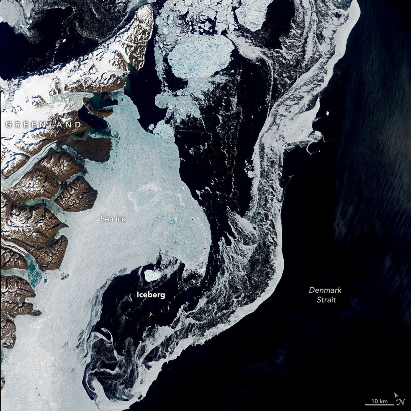
这些由Landsat 9上的OLI(陆地成像仪)拍摄的图像显示了6月12日该冰山在格陵兰岛和冰岛之间的海峡中漂流的情景。它位于格陵兰岛东海岸Kangikajiip Appalia海角以南,在场景左上方可见,周围混合着被称为“冰山混合区(mélange)”的海冰和冰山碎片。
These images, captured by the OLI (Operational Land Imager) on Landsat 9, show the iceberg on June 12 as it drifted in the strait between Greenland and Iceland. It was just south of Kangikajiip Appalia, a cape on Greenland’s east coast visible in the scene’s upper left, amid a mixture of sea ice and berg fragments known as “mélange.”
国际冰情巡逻队(International Ice Patrol)的海洋学家兼首席科学家Alexis Denton指出,有几个线索表明这是一座冰山,而不是厚重的多年生海冰:它靠近海岸,颜色更白,且与周围的海冰相比体积更大。6月12日,这座冰山的面积约为17平方公里(7平方英里),大约是纽约中央公园面积的五倍。与从南极冰川和冰架上崩解出的巨型冰山相比,这算不上什么,但以格陵兰岛的标准来看,它已经很大了。
Alexis Denton, oceanographer and chief scientist with the International Ice Patrol, noted that several clues indicate it is an iceberg rather than thick, multi-year sea ice: its proximity to shore, its whiter color, and larger size compared to the surrounding sea ice. Measuring roughly 17 square kilometers (7 square miles) on June 12, the iceberg was about five times the area of New York City's Central Park. That’s modest compared to the behemoth bergs that calve from Antarctic glaciers and ice shelves but large by Greenland standards.
丹麦气象研究所(Danish Meteorological Institute)格陵兰冰服务中心的高级冰顾问Keld Quistgaard指出,它起源于格陵兰岛东北部的Jøkelbugten海湾。然而,该冰山在海湾内的确切起源仍然是一个谜。冰山有可能从Zachariæ Isstrøm冰川或其邻近的残余冰架上断裂。该冰架曾与Zachariæ Isstrøm冰川一起填满了整个海湾,但在21世纪初冰川迅速退缩后被废弃。
Keld Quistgaard, a senior ice advisor with the Danish Meteorological Institute’s Greenland Ice Service, noted that it originated in Jøkelbugten—a bay in northeastern Greenland. The berg’s precise origin within that bay, however, remains something of a mystery. It’s possible that the berg broke off from Zachariæ Isstrøm or its adjacent remnant ice shelf. The ice shelf, which together with Zachariæ Isstrøm once filled the bay, was abandoned after the glacier rapidly retreated in the early 2000s.
通过卫星图像追踪其路径具有挑战性。整个春季,海湾及周边沿海地区都被海冰和冰山碎片堵塞,使得单个冰山难以辨认,尤其是当它们被明亮的积雪覆盖时。例如,在5月下旬,该冰山周围环绕着许多外观相似的冰块。直到季节后期,随着它向南漂流得更远,周围的冰层变薄,它才变得足够清晰,容易被发现。
Tracing its path back through satellite imagery is challenging. Through spring, the bay and surrounding coastal areas are choked with sea ice and berg fragments, making individual bergs hard to distinguish, especially if covered in bright snow. In late May, for instance, the berg was surrounded by numerous look-alikes. Only later in the season, as it drifted farther south and the ice around it thinned out, did it become distinct enough to easily spot.
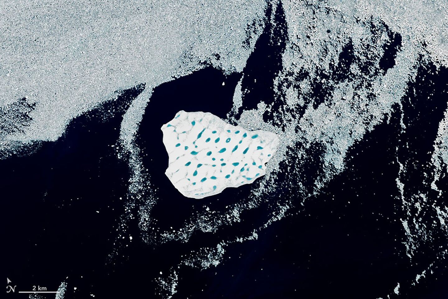
马里兰大学(University of Maryland)退休冰川学家Christopher Shuman表示,其体积和引人注目的蓝色融水池网络为推断其起源提供了一些线索。Shuman认为,冰山是从残余冰架上断裂的,而不是从冰川本身断裂的。他说,从Zachariæ Isstrøm冰川崩解出的冰山往往较小。此外,冰山的表面布满了融水池,“就像瑞士奶酪一样”,与残余的冰架非常相似。过去的卫星图像显示,那些冰架的碎片向南漂流,并被困在海湾边缘的岛屿之间,多年来一直受到风和潮汐的挤压。
Its size and striking network of blue meltwater ponds offer some clues to its origin, according to Christopher Shuman, a retired University of Maryland glaciologist. Shuman thinks the berg broke from the remnant ice shelf rather than the glacier itself. Bergs calved from Zachariæ Isstrøm tend to be smaller, he said. Also, the berg’s surface—pocked with meltwater ponds, "like Swiss cheese"—closely resembles the remnant shelf ice. Past satellite images show pieces of that shelf ice drifting south and getting trapped among islands bordering the bay, where winds and tides have jostled them for years.
截至8月中旬,该冰山距离海湾约1,500公里(900英里),正沿着格陵兰沿岸流(Greenland Coastal Current)向南漂入北大西洋。Quistgaard预计这座冰山将在整个月内逐渐解体。最近的卫星图像显示,它确实正在经历这一过程。
As of mid-August, the berg was about 1,500 kilometers (900 miles) from the bay, drifting south on the Greenland Coastal Current into the North Atlantic. Quistgaard expected the iceberg to gradually disintegrate throughout the month. Recent satellite imagery suggested it was doing just that.
在丹麦海峡解体意味着冰山的残骸不太可能漂入格陵兰岛南端繁忙的航道。“它的旅程提醒我们地球是动态的,”Shuman说,“同时也提醒我们北大西洋这一地区冰层的季节性变化。”
Breaking up in the Denmark Strait means that remnants of the berg are unlikely to drift into busier shipping lanes that go past the southern tip of Greenland. “Its journey is a reminder of the dynamic Earth,” Shuman said, “as well as the seasonal variability of the ice in this part of the North Atlantic.”
图注:美国国家航天局(NASA)地球天文台(Earth Observatory)图像由Lauren Dauphin制作,使用了美国地质调查局(U.S. Geological Survey)的Landsat数据。文章由Kathryn Hansen撰写。
NASA Earth Observatory images by Lauren Dauphin, using Landsat data from the U.S. Geological Survey. Story by Kathryn Hansen.
参考文献与资源
References & Resources
- NASA地球天文台(2015年12月4日)Zachariæ Isstrøm冰川,格陵兰岛。访问日期:2026年8月19日。
- NASA Earth Observatory (2015, December 4) Zachariæ Isstrøm Glacier, Greenland. Accessed August 19, 2026.
- Sutherland, D. A., and Pickart, R. S. (2008). 东格陵兰沿岸流:结构、变率与强迫。海洋学进展(Progress in Oceanography),78(1), 58-77。
- Sutherland, D. A., and Pickart, R. S. (2008). The East Greenland Coastal Current: Structure, variability, and forcing. Progress in Oceanography, 78(1), 58-77.
来源与许可
原文来自公共领域来源;译文由机器生成,请以原文为准。 原始页面