
查看原文全部插图(14 幅)






内容提要
飓风 Lala 在 2026 年 8 月中旬经过夏威夷群岛南部,造成了严重的降雨、洪水及基础设施破坏。此次风暴活动与厄尔尼诺现象期间的典型气候模式相符。
原文全文译文
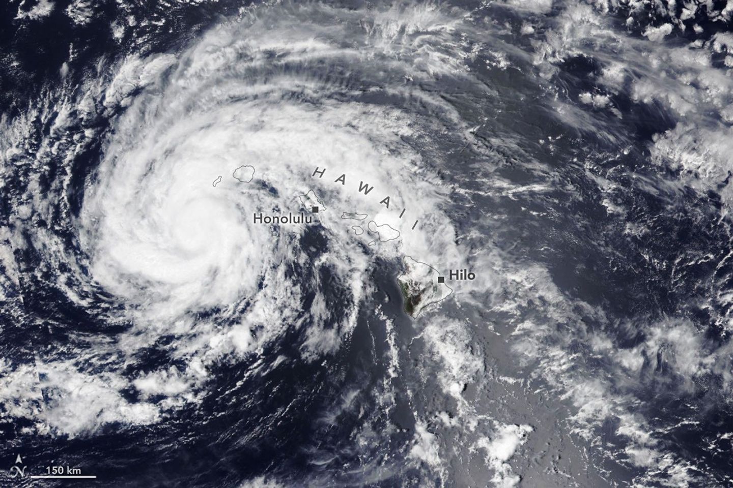
夏威夷岛在 2026 年 8 月中旬险些遭遇飓风 Lala 的直接登陆。尽管如此,该风暴在 8 月 15 日以萨菲尔-辛普森飓风风力等级(Saffir-Simpson wind scale)中的 1 级风暴强度从该岛南部掠过时,仍造成了严重破坏。
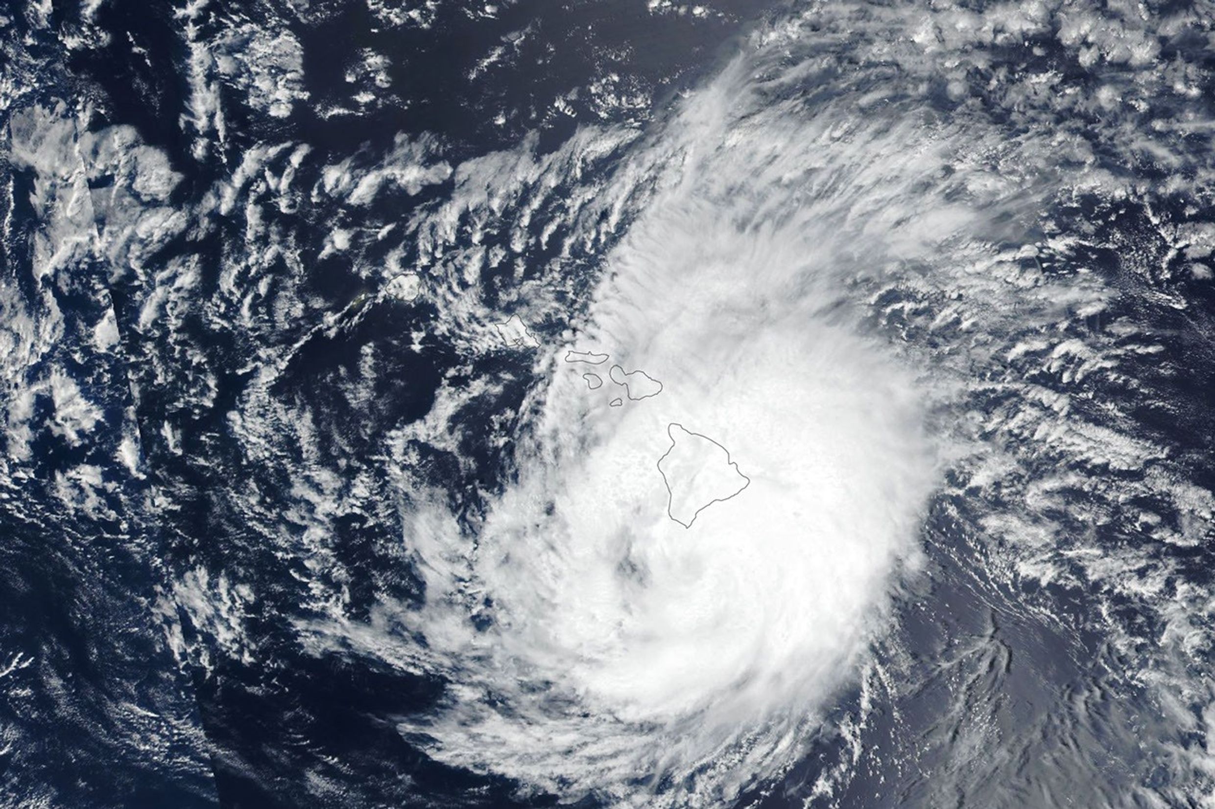
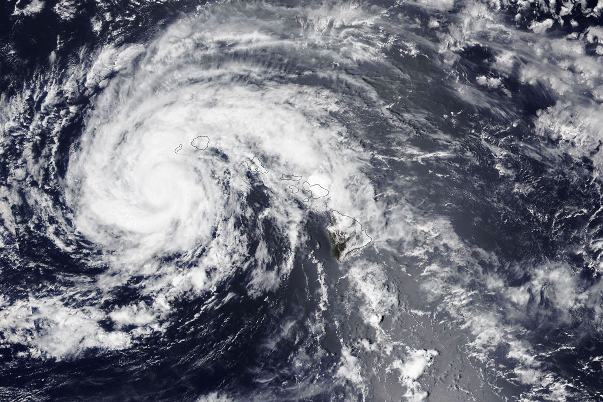
The Island of Hawaiʻi narrowly avoided a direct landfall by Hurricane Lala in mid-August 2026. The storm nonetheless delivered serious damage as it passed just south of the island on August 15 (above, right) as a category 1 storm on the Saffir-Simpson wind scale.
图注:
Lala brought rainfall totals exceeding 20 inches (50 centimeters) to parts of the island, causing flash flooding and ongoing mudflow risks. The highest rainfall total for the storm—43.55 inches (110.6 centimeters) as of the morning of August 17—was recorded at Laupāhoehoe, on the coast northwest of Hilo. Lala downed trees, damaged bridges, and knocked homes off their foundations. Coastal areas were pummeled by large waves, while the summit of Mauna Kea, over 13,000 feet (4,000 meters) above sea level, experienced blizzard conditions.
Lala 为该岛部分地区带来了超过 20 英寸(50 厘米)的降雨量,引发了山洪暴发并持续存在泥石流风险。截至 8 月 17 日上午,该风暴在希洛(Hilo)西北海岸的劳帕霍霍埃(Laupāhoehoe)记录到了 43.55 英寸(110.6 厘米)的最高降雨量。Lala 吹倒了树木,损坏了桥梁,并将房屋从地基上掀翻。沿海地区受到巨浪冲击,而海拔超过 13,000 英尺(4,000 米)的海平面(sea level)以上的冒纳凯阿火山(Mauna Kea)山顶则出现了暴风雪天气。
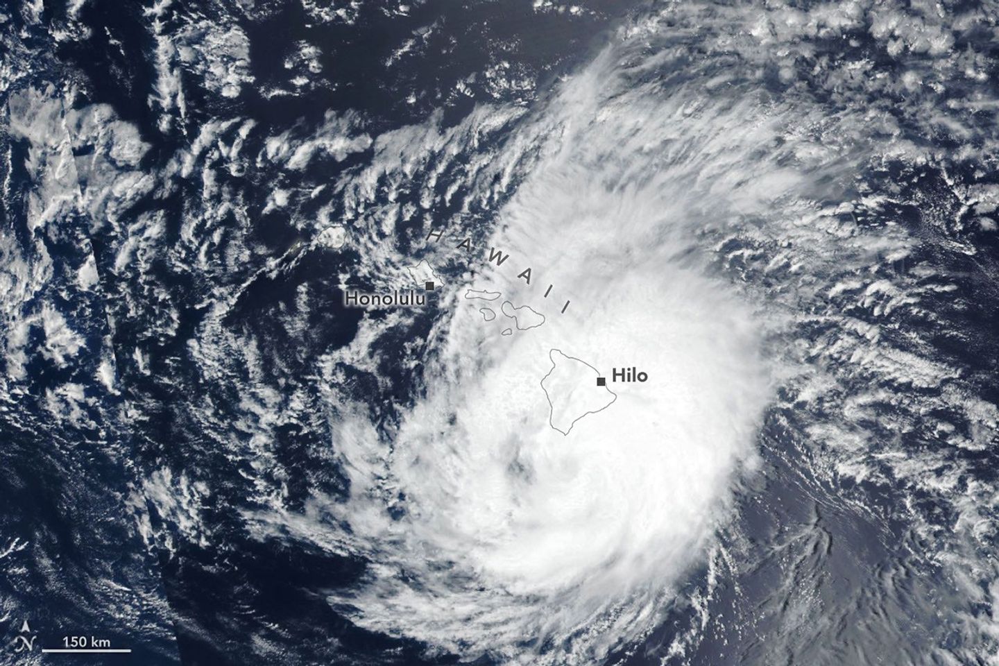
By early afternoon on August 16, when the other image (left) was acquired, the storm had tracked northwest, roughly parallel to the island chain, and was southwest of Kauaʻi. Lala had decreased in intensity to a tropical storm, with sustained winds of 65 miles (105 kilometers) per hour, according to the National Hurricane Center.
到 8 月 16 日下午早些时候,即拍摄另一张图像(左)时,风暴已向西北方向移动,大致与岛链平行,并位于考艾岛(Kauaʻi)西南方。据美国国家飓风中心(National Hurricane Center)称,Lala 的强度已减弱为热带风暴,持续风速为每小时 65 英里(105 公里)。
While the Island of Hawaiʻi took the brunt of the storm, other islands also saw destructive effects. Strong winds caused widespread power outages, with more than 220,000 customers statewide without power as of the afternoon of August 16, according to news reports. Across the islands, wind and rain damaged infrastructure, and floodwaters and debris rendered roads impassable.
虽然夏威夷岛承受了风暴的主要冲击,但其他岛屿也受到了破坏性影响。据新闻报道,强风导致了大范围停电,截至 8 月 16 日下午,全州有超过 220,000 名用户断电。在各岛屿上,风雨损坏了基础设施,洪水和碎片导致道路无法通行。
It has been an active tropical cyclone season in the Eastern Pacific so far in 2026, meteorologists note, consistent with what scientists expect during an El Niño, which has been underway as of mid-June. Warm water in the equatorial Pacific—the hallmark of El Niño—and the moisture and energy it transfers to the atmosphere help fuel nascent tropical storms. Lack of wind shear, another typical El Niño pattern in this region, also encourages tropical storms to develop and strengthen. The Atlantic hurricane season, in contrast, has been relatively calm, as greater wind shear over the Atlantic Ocean and Caribbean Sea during an El Niño inhibits hurricane formation by dissipating the upward motion of heat.
气象学家指出,2026 年迄今为止,东太平洋的热带气旋季节一直很活跃,这与科学家在厄尔尼诺(El Niño)期间的预期一致,该现象自 6 月中旬以来一直在持续。赤道太平洋的暖水是厄尔尼诺的标志,它向大气输送的水分和能量有助于助长初生的热带风暴。缺乏风切变(wind shear)是该地区厄尔尼诺现象的另一个典型模式,也促使热带风暴得以发展和增强。相比之下,大西洋飓风季节相对平静,因为厄尔尼诺期间大西洋和加勒比海上的风切变较强,通过消散向上的热量运动抑制了飓风的形成。
NASA Earth Observatory images by Lauren Dauphin, using VIIRS data from NASA EOSDIS LANCE, GIBS/Worldview, and the Joint Polar Satellite System (JPSS). Story by Lindsey Doermann.
美国国家航天局(NASA)地球(Earth)天文台(Observatory)图像由 Lauren Dauphin 制作,使用了来自美国国家航天局地球观测系统数据与信息系统(NASA EOSDIS)LANCE、GIBS/Worldview 以及联合极轨卫星系(Joint Polar Satellite System,JPSS)的 VIIRS 数据。报道由 Lindsey Doermann 撰写。
References & Resources
- AccuWeather (2026, August 17) Lala's recent close encounter with Hawaii continues to cause trouble Monday. Accessed August 17, 2026.
- Colorado State University (2026, August 17) Northern Hemisphere Tropical Cyclone Activity for 2026. Accessed August 17, 2026.
- Honolulu Civil Beat (2026, August 16) Lala’s Wrath: Homes Swept Away, Some Power Outages May Last Months. Accessed August 17, 2026.
- National Hurricane Center (2026, August 17) Hurricane LALA Advisory Archive. Accessed August 17, 2026.
- Yale Climate Connections (2026, August 12) Tropical Storm Lala heads toward Hawaii; life-threatening floods possible. Accessed August 17, 2026.
来源与许可
原文来自公共领域来源;译文由机器生成,请以原文为准。 原始页面