
查看原文全部插图(14 幅)




内容提要
2026年8月,格陵兰岛彼得曼冰川发生了一次大规模冰山崩解事件,产生了一座巨大的冰岛。该冰岛在漂流过程中与乔岛发生碰撞,但并未发生进一步破碎。科学家正通过遥感技术密切监测其后续动向及其对海平面上升的影响。
原文全文译文
夏季是格陵兰岛冰川峡湾中冰山活动的高峰期,2026年也不例外。其中最引人注目的是8月从格陵兰岛西北海岸彼得曼冰川(Petermann Glacier)崩解出的冰山。其面积大致相当于美属维尔京群岛的圣托马斯岛,是自2020年以来北极冰川发生的最大规模崩解事件。
Summer is prime iceberg season in Greenland’s glacier-fed fjords, and 2026 was no exception. Especially notable was the berg that broke from the Petermann Glacier along Greenland’s northwest coast in August. Roughly the size of St. Thomas in the U.S. Virgin Islands, it was the largest calving event by any Arctic glacier since 2020.
冰山崩解是出海冰川生命周期中的常规部分。然而,科学家们会密切关注这一过程,并结合对冰层及其环境的众多其他观测,以寻找长期不稳定的迹象。彼得曼冰川是格陵兰岛最大的海洋终点冰川之一,也是冰层从冰盖流入海洋的“守门人”。其未来的稳定性对海平面(sea level)上升具有重要意义。
Iceberg calving is a routine part of an outlet glacier’s life cycle. Scientists watch the process closely, however, along with numerous other observations of the ice and its environment, for longer-term signs of instability. Petermann is one of Greenland's largest marine-terminating glaciers and acts as a gatekeeper for ice flowing from the ice sheet into the ocean. Its future stability has implications for sea level rise.
2026年夏季的这次崩解事件由渥太华大学冰川学博士生Adam Garbo于8月4日发现,他使用了来自欧洲空间局(European Space Agency, ESA)Sentinel-1任务的影像。Garbo及其国际同事团队一直利用遥感(remote sensing)技术来研究和追踪该冰川的冰舌。
The calving event of summer 2026 was spotted on August 4 by Adam Garbo, a doctoral student in glaciology at the University of Ottawa, in imagery from the European Space Agency's Sentinel-1 mission. Garbo and an international team of colleagues have been using remote sensing to study and track the glacier's ice tongue.
研究团队报告称,这座巨大的平顶冰山,即“冰岛”,在崩解时面积略超过76平方公里(29平方英里),是自2012年冰岛(130平方公里)以来从该冰川崩解出的最大冰山。2012年的崩解事件之前,还曾发生过2008年(31平方公里)和2010年(超过250平方公里)的重大事件。
The team reported that the large tabular iceberg, or “ice island,” measured just over 76 square kilometers (29 square miles) at the time it calved—the largest to break from the glacier since the ice island of 2012 (130 square kilometers). The 2012 calving followed earlier major events in 2008 (31 square kilometers) and 2010 (just over 250 square kilometers).
2026年8月的这次事件本可能规模更大。Garbo和同事们曾预计,一旦他们监测的其中一条大裂缝完全切穿彼得曼冰川的冰舌,就会发生大规模崩解。“令我们惊讶的是,崩解过程沿着另一条裂缝发生,产生的冰岛比我们最初预期的要小,”Garbo说。截至8月下旬,仍有两条大裂缝存在,预计最终将产生面积分别约为94平方公里和84平方公里的新冰岛,尽管具体时间尚不确定。
The August 2026 event could have been even bigger. Garbo and colleagues had been expecting a major calving once one of the large rifts they were monitoring finally cut all the way across Petermann’s ice tongue. “What surprised us was that the calving instead followed a different fracture, producing a smaller ice island than we had originally anticipated,” Garbo said. As of late August, two large rifts remained and were expected to eventually produce new ice islands of roughly 94 square kilometers and 84 square kilometers, though the timing remained uncertain.
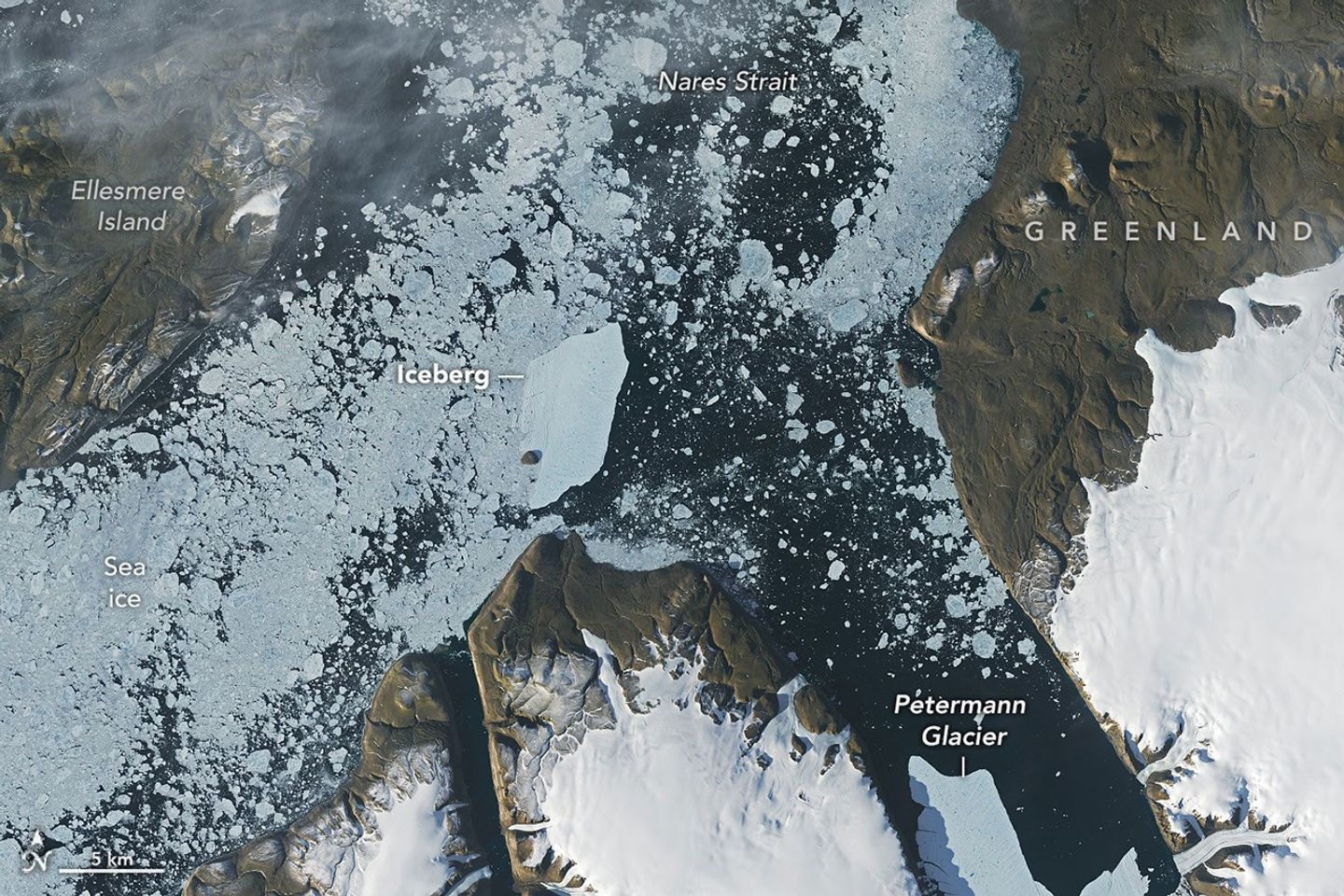
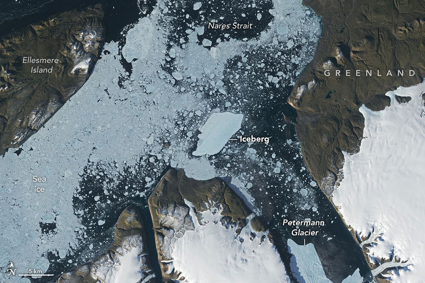
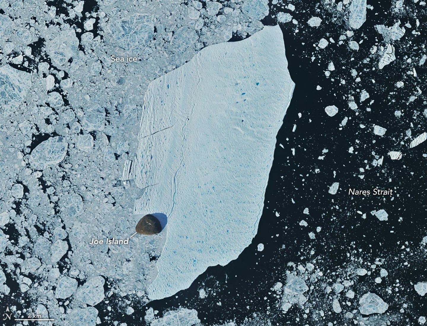
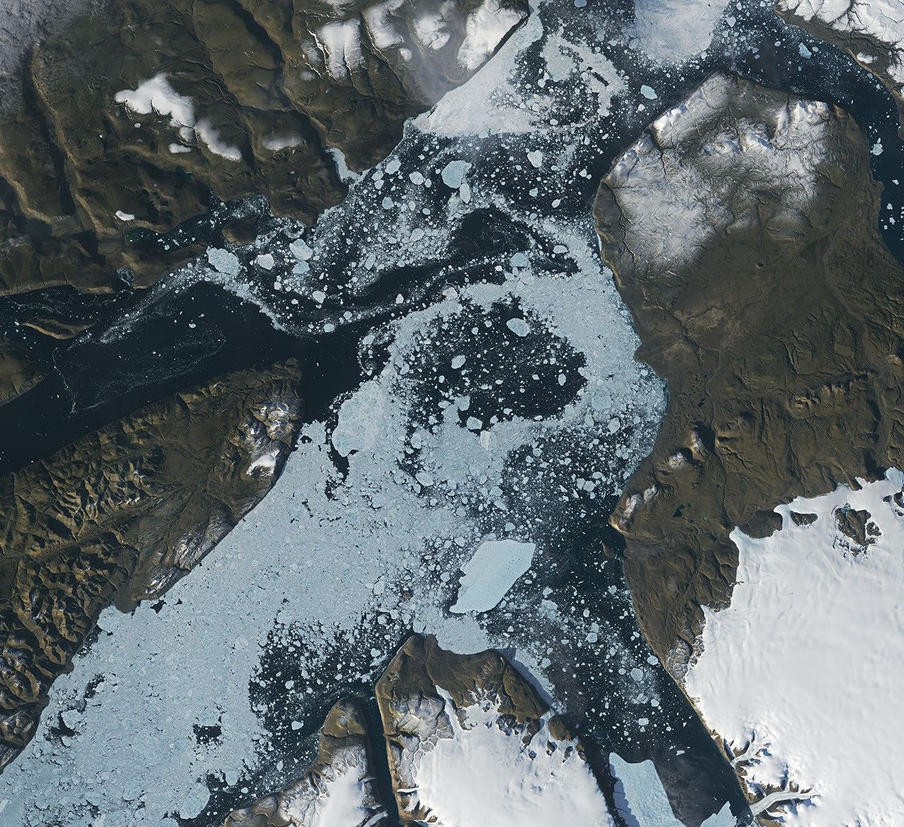
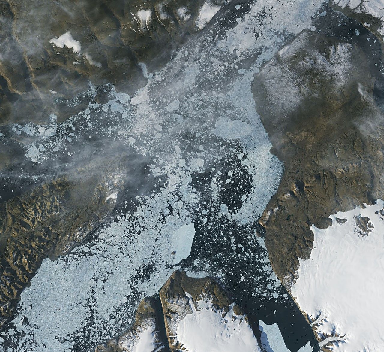
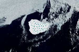
尼科尔斯学院的冰川学家Mauri Pelto也一直在利用美国国家航天局(NASA)与美国地质调查局(USGS)的Landsat卫星图像追踪这座冰山,它正沿着彼得曼峡湾向内尔斯海峡(Nares Strait)漂流。在崩解后的一周内,该冰山平均每天漂流3公里。它继续向峡湾与内尔斯海峡的交汇处移动,并在那里撞上了一处被称为乔岛(Joe Island/Joe Ø)的小型岩石露头。8月23日(右上)和8月24日(左上)由Landsat 9卫星上的OLI(陆地成像仪)捕获的图像显示了这次短暂的碰撞。上方展示了8月24日图像的详细视图。
Glaciologist Mauri Pelto of Nichols College has also been tracking the iceberg, using images from NASA-USGS Landsat satellites, as it drifted down Petermann Fjord toward Nares Strait. In the week since it calved, the berg drifted an average of 3 kilometers per day. It continued toward the fjord’s junction with Nares Strait, where it rammed into a small rocky outcrop known as Joe Island (Joe Ø). The brief encounter is visible in images captured by the OLI (Operational Land Imager) on Landsat 9 on August 23 (top right) and August 24 (top left). A detailed view of the August 24 image is shown above.
乔岛位于彼得曼峡湾的入口处,使其成为离去的冰岛遇到的第一道障碍之一。与它的碰撞——就像2010年将那座冰岛一分为二的碰撞一样——往往标志着冰山解体的开始。Pelto指出,彼得曼冰川产生的冰山往往比格陵兰岛雅各布港(Jakobshavn)和赫尔海姆(Helheim)等冰川崩解出的冰山更薄、更脆弱,比南极洲的巨型冰山则更薄。
Joe Island sits at the mouth of Petermann Fjord, making it one of the first obstacles a departing ice island meets. Collisions with it—like the one that split the 2010 ice island in two—often mark the start of a berg’s breakup. Petermann bergs tend to be thinner and more fragile than those calved by glaciers such as Greenland’s Jakobshavn and Helheim, and thinner still than Antarctica’s behemoths, Pelto noted.
“我们当然在密切关注它与乔岛的相互作用,并对其在没有进一步破碎的情况下幸存下来印象深刻,”Garbo说。
“We were certainly watching closely as it interacted with Joe Island and were impressed that it survived the interaction without further fragmentation,” Garbo said.
据估计,该冰岛在崩解时厚度不到150米。风和表层洋流已将其从峡湾中吹出,卫星图像显示它正绕过乔岛,继续向西南方向穿过内尔斯海峡。随着它的漂流,潮汐、风、洋流和融化将继续削弱冰层,导致其破碎成更小的碎片。
The ice island was estimated to be less than 150 meters thick at the time of calving. Wind and surface currents have swept it out of the fjord, and satellite images show it pivoting away from Joe Island and continuing southwest through Nares Strait. As it drifts, it will fracture into smaller pieces as tides, winds, currents, and melting continue to weaken the ice.
从没有浮动冰架延伸的潮汐冰川崩解出的较厚冰山,可能会在峡湾内拖曳甚至搁浅在海底,而像彼得曼冰川产生的这类冰岛,可能会在漂流后期搁浅。许多冰岛已经在科堡岛(Coburg Island)和巴芬岛(Baffin Island)沿岸“搁浅”。
Thicker bergs that calve from tidewater glaciers without floating ice-shelf extensions can drag and even become grounded on the seafloor within the fjord, while ice islands, like those from Petermann, might run aground later in their drift. Many ice islands have become "grounded" off the coasts of Coburg and Baffin islands.
Garbo和同事们指出,已知冰岛及其碎片可以漂流相当远的距离,对海上活动和基础设施构成潜在威胁,同时在融化过程中将淡水输送到海洋中。
Garbo and colleagues noted that ice islands and their fragments have been known to travel considerable distances, posing potential hazards to marine activities and infrastructure while also distributing freshwater through the ocean as they melt.
图注:美国国家航天局地球天文台(NASA Earth Observatory)图像由Lauren Dauphin制作,使用了美国地质调查局的Landsat数据。文章作者:Kathryn Hansen。
NASA Earth Observatory images by Lauren Dauphin, using Landsat data from the U.S. Geological Survey. Story by Kathryn Hansen.
参考文献与资源
References & Resources
- Åkesson, H., et al. (2022) Petermann ice shelf may not recover after a future breakup. Nature Communications, 13(2519).
- Åkesson, H., et al. (2022) Petermann ice shelf may not recover after a future breakup. Nature Communications, 13(2519).
- Crawford, A. J., et al. (2016) Journey of an Arctic Ice Island. Oceanography, 29(2), 254–263.
- Crawford, A. J., et al. (2016) Journey of an Arctic Ice Island. Oceanography, 29(2), 254–263.
- Eos (2011, April 5) Context for the Recent Massive Petermann Glacier Calving Event. Accessed August 28, 2026.
- Eos (2011, April 5) Context for the Recent Massive Petermann Glacier Calving Event. Accessed August 28, 2026.
- The European Space Agency (2026, August 21) Sentinel-1 captures major ice loss from Greenland glacier. Accessed August 28, 2026.
- The European Space Agency (2026, August 21) Sentinel-1 captures major ice loss from Greenland glacier. Accessed August 28, 2026.
- Fahrner, D., et al. (2026) Petermann Glacier on the brink: Progress, challenges and insights. Science Advances, 12(33).
- Fahrner, D., et al. (2026) Petermann Glacier on the brink: Progress, challenges and insights. Science Advances, 12(33).
- From a Glaciers Perspective (2026, August 17) Petermann Glacier, NW Greenland Releases Massive Iceberg in August 2026. Accessed August 28, 2026.
- From a Glaciers Perspective (2026, August 17) Petermann Glacier, NW Greenland Releases Massive Iceberg in August 2026. Accessed August 28, 2026.
- NASA Earth Observatory (2023, May 20) Retreat at Petermann Glacier. Accessed August 28, 2026.
- NASA Earth Observatory (2023, May 20) Retreat at Petermann Glacier. Accessed August 28, 2026.
- NASA Earth Observatory (2012, August 2) Ice Island Drifts away from Petermann Glacier. Accessed August 28, 2026.
- NASA Earth Observatory (2012, August 2) Ice Island Drifts away from Petermann Glacier. Accessed August 28, 2026.
- NASA Earth Observatory (2010, August 10) Ice Island calves off Petermann Glacier. Accessed August 28, 2026.
- NASA Earth Observatory (2010, August 10) Ice Island calves off Petermann Glacier. Accessed August 28, 2026.
- uOttawa (2026, August 7) Greenland glacier break creates new ice island. Accessed August 28, 2026.
- uOttawa (2026, August 7) Greenland glacier break creates new ice island. Accessed August 28, 2026.
来源与许可
原文来自公共领域来源;译文由机器生成,请以原文为准。 原始页面