查看原文全部插图(6 幅)

内容提要
Landsat科学团队成员、大气改正专家Eric Vermote因其在建立全球大气改正和数据验证标准方面的杰出贡献,荣获William T. Pecora奖。Vermote长期致力于提升地球观测数据的质量与可靠性,其开发的辐射转移算法已成为多项卫星任务的核心技术。
原文全文译文
Eric Vermote, Landsat Science Team Member, Wins Pecora Award
Eric Vermote, Landsat Science Team Member, Wins Pecora Award
2026年8月27日
August 27, 2026
今年5月,Landsat科学团队成员兼大气改正(atmospheric correction)专家Eric Vermote荣获William T. Pecora奖,以表彰他在制定全球大气改正和数据验证标准方面所作出的杰出贡献。
In May, Landsat Science Team member and atmospheric correction expert Eric Vermote won the William T. Pecora Award for his outstanding contributions set global standards for atmospheric correction and data validation.
Vermote将自己的职业生涯奉献给了提升地球(Earth)观测数据的质量与可靠性。当像Landsat这样的光学卫星(satellite)观测地球时,存在一个主要障碍:大气层。消除天电干扰(atmospheric interference,如灰尘、水蒸气和气溶胶)是获取地面清晰影像的关键。他在6S辐射转移(radiative transfer)代码(一种大气改正算法)方面的开创性工作,几十年来一直被各地球观测任务广泛使用,以生成一致且经过校准的数据。作为2026-2030年Landsat科学团队的一员,Vermote将继续维护和改进地表反射率代码(LaSRC),这是一种用于Landsat 8、Landsat 9、Harmonized Landsat and Sentinel-2 (HLS)数据集的大气改正算法,并为Landsat 10做好准备。这些算法共同使数据用户能够自信地比较跨年度的观测结果,并支持创建长期的全球数据记录。
Vermote has dedicated his career to improving the quality and reliability of Earth observation data. When optical satellites like Landsat observe the Earth, there’s one major obstacle in the way: the atmosphere. Removing atmospheric interference (like dust, water vapor, and aerosols) is key to getting a clear view of what’s happening on the ground. His pioneering work on the 6S radiative transfer code, an atmospheric correction algorithm, has been widely used by Earth observation missions to produce consistent and calibrated data over decades. As a member of the 2026-2030 Landsat Science Team, Vermote will continue to maintain and refine the Land Surface Reflectance Code (LaSRC), an atmospheric correction algorithm used for the Landsat 8, Landsat 9, Harmonized Landsat and Sentinel-2 (HLS) datasets, and prepare it for Landsat 10. Together, these algorithms allow data users to confidently compare observations taken across years and enable the creation of long-term global data records.
Vermote一直是Landsat计划的关键成员,包括担任Landsat数据连续性任务(LDCM)科学团队和HLS科学组的成员。在更广泛的机构层面,他是中分辨率成像光谱仪(MODIS)科学团队的成员,也是美国国家航天局(NASA)针对VIIRS仪器的美国国家极轨业务环境卫星系统预备项目(Suomi NPP)科学团队的成员。他的基础性工作对于NASA致力于提供地球观测数据黄金标准的核心承诺至关重要。
Vermote has been a key part of the Landsat program, including as a member of the Landsat Data Continuity Mission (LDCM) Science Team and the HLS Science Group. Across the wider agency, he is member of the Moderate Resolution Imaging Spectroradiometer (MODIS) Science Team and the NASA National Polar-orbiting Operational Environmental Satellite System Preparatory Project (Suomi NPP) Science Team for the VIIRS instrument. His foundational work is central to NASA’s commitment to providing the gold standard of Earth observation data
我们采访了Vermote,谈到了他获得Pecora奖、大气改正以及校准和验证的重要性:
We spoke to Vermote about winning the Pecora Award, atmospheric correction, and the importance of calibration and validation:
祝贺您获奖。这意义重大。当您得知获奖时是什么心情?感到惊讶吗?
Congratulations on the award. This is huge. How did you feel when you found out? Were you surprised?
是的,我很惊讶。我原以为今年NASA的人获奖的可能性非常小。后来当我得知Jim Irons也获奖时,我心想,哇,他们把奖颁给了两位NASA的人。所以,我们真的应该为该机构感到自豪。
Yeah, I was surprised. I thought that it was very unlikely that they would give it to a NASA guy this year. And then when I learned that Jim Irons got it too, I was like, wow, they gave it to two NASA guys. So, we should really be proud of the Agency.
大气改正并不是一个家喻户晓的术语,但它却是许多地球观测科学的基础。您如何向该领域之外的人解释它的重要性?您有什么好的类比来帮助人们理解这一挑战吗?
Atmospheric correction isn't a household term, yet it's fundamental to so much of Earth observation science. How do you explain its importance to someone outside the field? Do you have a favorite analogy for helping people understand that challenge?
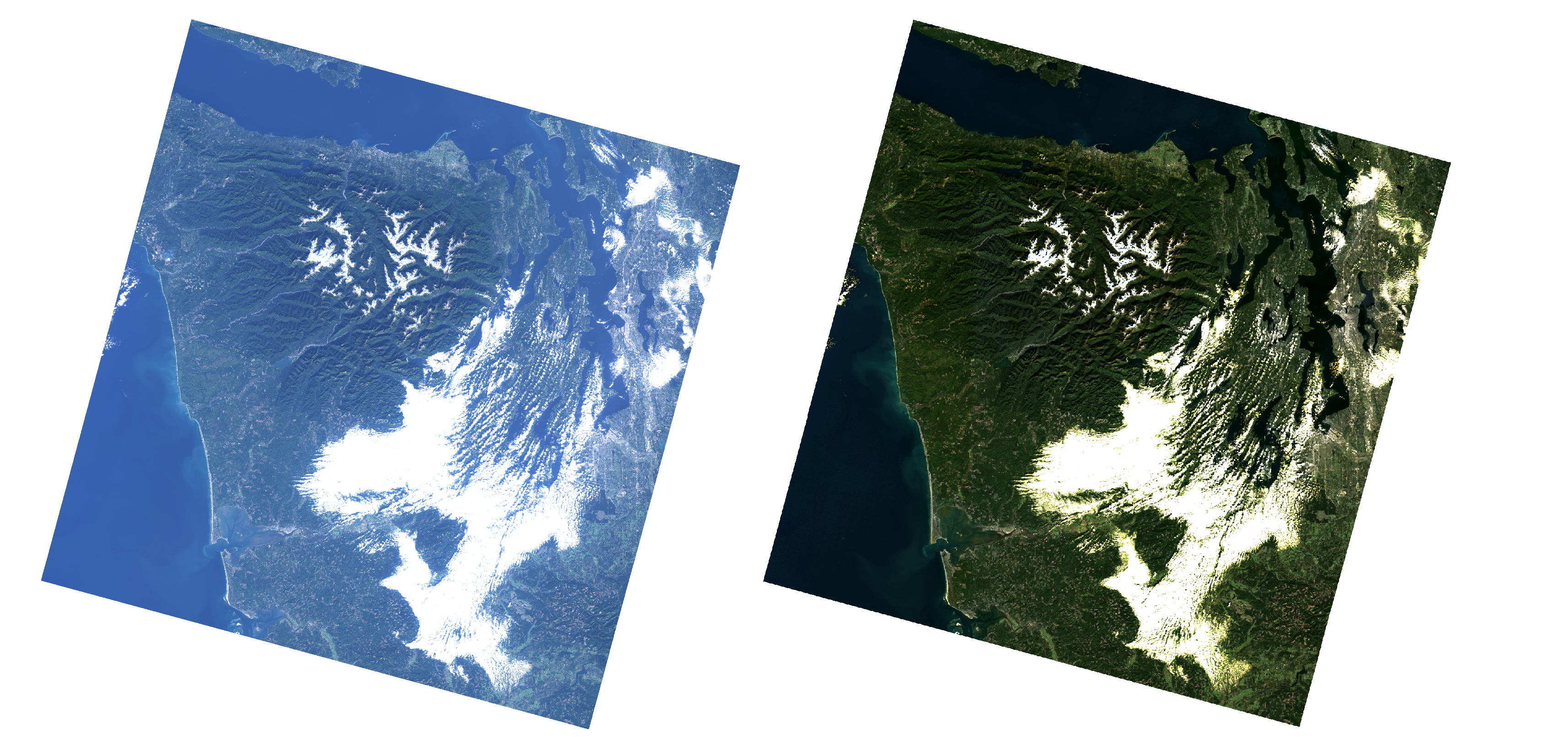
嗯,我认为最好的方法就是并排展示两张图片,一张没有经过大气改正,另一张经过了大气改正。特别是在真彩色模式下。即使在晴天,没有经过大气改正的图片也会显得有些模糊。
Well, I think that the best thing is just to show two pictures side to side, one without and one with atmospheric correction. Especially in true color. Even on a clear day, the one without atmospheric correction will be kind of blurry.
消除大气噪声(atmospheric noise)如何直接支持农业、监测和追踪环境变化等现实应用?
How does removing the atmospheric noise directly support real-world applications like agriculture, monitoring, and tracking environmental change?
首先,对于大多数应用,你确实需要了解地表的属性。如果你从太空观察地球表面,你会接收到一个大气信号,而你无法将从太空测量的结果与地面测量的结果联系起来。为了从地表获得纯净的信号,你需要对大气进行改正。从绝对意义上讲,你需要穿透大气层到达地表。
First of all, for most applications you really need to know the properties of the land surface. If you’re looking at the Earth’s surface from space, you have an atmospheric signal and you cannot relate what you measure from space to what you measure on the ground. To get a pure signal from the ground surface you need to correct for the atmosphere. In an absolute sense, you need to get through the atmosphere to the land surface.
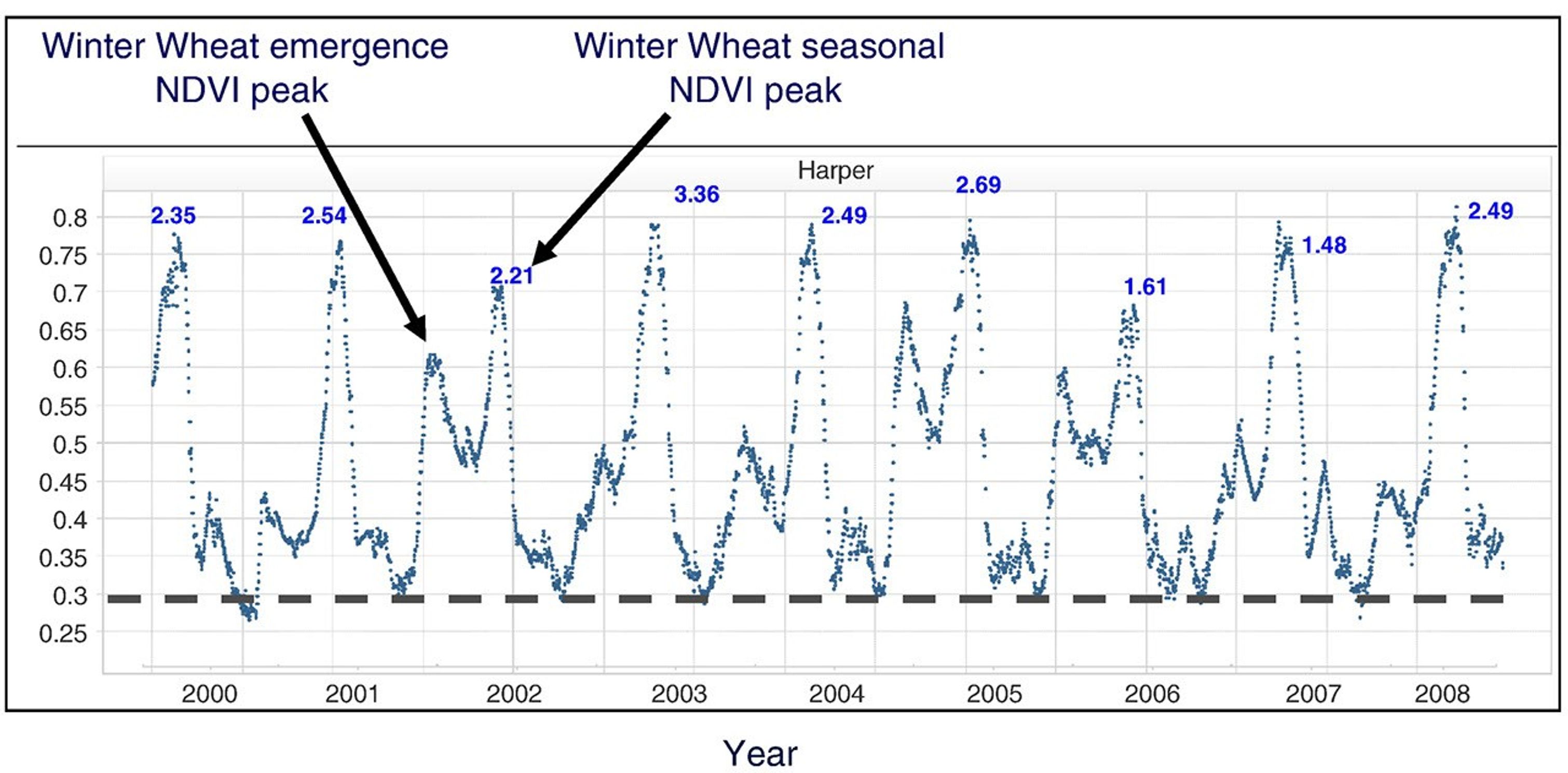
此外,由于各种原因,大气层每天都在变化。因此,时间序列数据中会出现噪声,这将阻碍你呈现地表的演变,例如农作物的生长(见下文Becker-Reshef等人于2010年的图表,其中数据已针对大气效应(atmospheric effect)进行了改正并进行了云层筛选)。
Also, the atmosphere varies from day to day for a variety of reasons. So, you will have noise in the time-series data that will prevent you from representing the evolution of the surface, such as the growth of crops (see figure below from Becker-Reshef et al., 2010, where data have been corrected for atmospheric effect and cloud screened).
所以,正是绝对性和时间性这两个方面使得大气改正成为必要。
So these two aspects, the absolute and the temporal that necessitate atmospheric correction.
为什么跨越几十年的卫星观测数据的校准和验证对于理解地球表面的变化如此关键?
Why are calibration and validation across decades of satellite observations so critical for understanding the changes on Earth's surface?
这非常关键,举一个简单的例子:要研究几十年的地表变化,你需要使用来自多个仪器的数据。如果你没有精确的校准,当你从一个仪器切换到另一个仪器时,你会看到变化。我记得在使用美国国家海洋和大气管理局(NOAA)的AVHRR系列卫星时,我可以查看所有AVHRR数据,并能分辨出:“哦,那是NOAA-7,那是NOAA-9,那是NOAA-11。”它们有各自的特征,因为它们没有经过校准。如果你想汇编一个长期一致的时间序列,拥有良好的校准至关重要。
It's critical because, in a very simple example: to study land surface change over decades you will need to use data from multiple instruments. If you don't have accurate calibration, as you move from one instrument to another, you will see a change. I remember with the NOAA AVHRR series of satellites, I could look at all the AVHRR data and I could tell you, "Oh yeah, that's NOAA-7, that's NOAA-9, that's NOAA-11." They had their own signature because they were not calibrated. If you want to assemble a long-term consistent time series, it's critical to have a good calibration.
当然,验证也至关重要,因为没有验证(精度评估),一切都无从谈起。我记得当我们最初开发MODIS的地表产品时,我们都很兴奋,我们开发的所有算法都非常出色。在经过一两年的数据积累后,NASA说:“好了,现在是验证这些产品的时候了,”每个人都脸色苍白。我们喜欢开发算法,但验证它们要复杂得多,也更耗时。但归根结底,这才是让你对所生产的产品产生信心的原因。没有其他办法。
And of course, validation also is critical because without validation (accuracy assessment) there's nothing. I remember when we were first developing land products from MODIS, we were all excited, and had all these algorithms we had developed, they were superb. After a year or two of data, NASA said, "OK, now it's time to validate the products," and everybody went pale. We like to develop algorithms, but validating them is much more complicated and time-consuming. But at the end of the day, that's what brings you confidence in what you produce. There's no other way.
我们经常听到校准和验证被合称为Cal/Val。验证与校准有何不同,为什么这很重要?
We often hear Calibration and Validation referenced together as Cal/Val. What is so different about a validation from calibration and why is that important?
井宿(Well),仪器校准通常处于第一层级。因此,你需要处理那些数字计数值的数据,并将它们校准为物理单位(发射率或反射率)。这是第一步。从那里开始,你得到了一个经过校准的信号,但它仍然是原始的。你还没有得到一个产品。所以,如果你想观察海洋中的叶绿素,或者陆地表面的植被组成,你首先需要进行大气改正(atmospheric correction)。在此之后,你需要提出一种算法来生成衍生产品。最终产品可以是叶绿素含量,例如,然后你需要验证它,或者量化产品的准确性。你可以通过在地面进行独立测量,并将它们与你从信号中反演出的结果进行相关联来验证产品。因此,验证是校准之后的一步。但是没有校准就没有验证。这就是为什么我们总是进行校准与验证(Cal Val)。
Well, instrument calibration is usually at the first level. So, you go to data which are digital counts and you calibrate them into physical units (emissivity or reflectance). That's the first step. And from there you have a calibrated signal, but it's still raw. You don't have a product. So, if you want to look at the chlorophyll in the ocean, or vegetation composition on the land surface, you first need to do the atmospheric correction. And after that you need to come up with an algorithm to make a derived product. The final product could be chlorophyll content, for example, and you then need to validate it, or quantify the accuracy of the product. You can validate products by taking independent measurements on the ground and correlating them with what you have inverted from the signal. So, validation is one step beyond calibration. But you don't have validation without calibration. So that's why we always have Cal Val.
你为陆地表面开发的6S辐射转移(radiative transfer)代码已成为多个任务的标准。当你最初开发这些工具时,你是否想象过它们会产生如此广泛而持久的影响?
Your development of the 6S radiative transfer code for the land surface has become a standard across multiple missions. When you first developed these tools, did you imagine they would have such a broad and lasting impact?
不,不,我没有。我的意思是,首先,当我开始攻读博士学位时,已经有了5S代码。他们给我的第一件事就是5S代码的手册,他们说,因为你九月份才开始,在假期期间,就把那个读一下。我一个字也看不懂。我试着去读它。我对我在做什么有一个模糊的概念。
No, no, I didn't. I mean, first of all, when I started my PhD there was the 5S code. The first thing they gave me was the manual for the 5S code and they said, because you're only starting in September, during your vacation, just read that. And I couldn't understand a word of it. I tried to read it. I had a vague idea of what I was working on.
当我攻读博士学位时,我处理了4到5张图像,比如说5张。就是这样。我从未想象过在某个时候我会处理如此多的全球数据,并能够将该代码应用于全球时间序列。
When I did my PhD, I worked on 4 to 5 images, let's say 5. That's it. I never imagined that at some point I would work on so much data globally and be able to apply the code to global time-series.
在你的职业生涯中,你协调了来自不同传感器和机构的数据。使来自不同卫星的观测结果真正具有可比性,最大的挑战是什么?
Throughout your career, you've harmonized data across different sensors and agencies. What were the biggest challenges in making observations from different satellites truly comparable?
第一个是校准。仪器校准规范通常在±2%左右,这意味着对于最好的传感器,如果你运气不好,来自两个不同传感器的测量结果可能会有4%的差异。而用户通常希望差异小于1%。因此,在协调中,你需要选择一个标准,并需要协调每个传感器的校准。这其中存在复杂性,因为它们没有相同的光谱响应(spectral response),也没有相同的获取几何结构。光谱响应的差异是一个巨大的挑战。你需要从一开始就做正确的事情,然后尽可能地协调它们,但不要让它们看起来一模一样。它们确实需要以一种非常科学和谨慎的方式进行协调。这最终应该匹配,但必须是有充分理由的。
The first one is calibration. Instrument calibration specification is often around ±2%, and that means for the best sensors, if you're not lucky, measurements from two different sensors can differ by 4%. And the user usually wants less than 1%. So in harmonization, you need to choose a standard and you need to harmonize the calibration of every sensor. There is complication in that because they don't have the same spectral response, they don't have the same acquisition geometry. Differences in spectral response is a big challenge. You need to do things right from the beginning, and then harmonize them as much as you can, but not making them look alike. They really need to be harmonized in a very scientific and careful way. This should match at the end, but for good reason.
你的LaSRC代码目前被用于创建HLS产品。在你看来,为什么HLS数据产品在地球科学界如此受欢迎且重要?
Your LaSRC code is currently used in the creation of the HLS product. In your eyes, why is the HLS data product so popular and important for the Earth Science community?
因为它通过协调带来了空间分辨率(spatial resolution)、数据质量以及组成它的传感器,从而产生了一个丰富的中等分辨率时间序列。而且它仍然非常、非常准确。所以对于用户来说,这是他们可以随时使用的东西。它确实是ARD——分析就绪数据——用户不必提出任何问题。他们可以直接使用这些数据。他们可以信任它。并且他们拥有高时间分辨率(temporal resolution)、空间分辨率和谱分辨率(spectral resolution)。他们有很多可以利用的东西。
Because it brings the spatial resolution, the quality of the data, and the sensors it's composed of through harmonization, leading to a rich moderate resolution temporal time series. And it’s still very, very accurate. So for the user, it's something that they can readily use. It's truly ARD—analysis ready data—and users don't have to ask any questions. They just can use the data. They can trust it. And they have the high temporal resolution, the spatial resolution and the spectral resolution. They have a lot of things they can work with.
你花了数十年时间帮助我们从太空更清晰地观察地球表面。你认为大气改正的下一个重大前沿或挑战是什么?
You've spent decades helping us see Earth's surface more clearly from space. What do you see as the next big frontier or challenge for atmospheric correction?
一切都在细节中。我们可以谈论方向效应与大气效应(atmospheric effect)之间的耦合、大气点扩散函数(point spread function)、诸如此类的事情。地形。这是我们仍然需要改进的地方。这是一种二阶效应,但人们会想要越来越好的数据,所以我们将不得不处理它。过去,我们甚至没有计算能力来进行那种高级校准,所以我们甚至没有尝试,因为没有办法在业务上实现它。但如今,随着计算能力的进步,我们可以设想进行那种校准。
It's all in the details. We can talk about the coupling between the directional effect and the atmospheric effect, the atmospheric point spread function, things like that. Topography. That's the kind of thing we still need to improve. It's a second-tier effect, but people are going to want better and better data, so we're going to have to deal with it. In the past, we did not even have the computing capability to do those kinds of advanced corrections, so we didn't even try because there was no way to do it operationally. But nowadays, with all the advances in computing capability, we can envision doing those kinds of corrections.
你的工作还涉及与AERONET网络的合作,这是一个帮助建立通用标准和验证方法的国际合作伙伴。为什么国际合作对地球观测如此重要?
Your work also involves collaboration with the AERONET network, an international partners to help establish common standards and validation methods. Why is international collaboration so important for Earth observation?
以AERONET为例。你需要到处设置站点,而不仅仅是在美国国家航天局(NASA)戈达德太空飞行中心附近。你需要把它们放在难以进入和维护仪器的地方。对于网络中的每一台仪器,你都需要一名站点管理员。即使它是最好的仪器,有时你知道会有管子里有蜘蛛的故事,或者仪器旋转太多而挂在自己的电缆上,或者任何事情都可能发生。所以你需要现场有人去检查仪器,这通常是国际合作伙伴。你不能在每个站点都安排一名NASA员工,尽管我很想去法国照顾一台仪器。(笑)当你拥有一个全球数据集时,你需要一个全球网络和国际合作伙伴来实施它。
Take the example of AERONET. You need to put stations everywhere, not only near NASA Goddard. You need to put them in places where it's challenging to access and maintain the instruments. For every instrument in the network, you need a site manager. Even if it's the best instrument, sometimes you know there's a story of the spider in the tube, or the instrument just rotating too much and getting hung up on its own cable, or anything could happen. So you need somebody on site who can go check the instrument and that's usually an international partner. You cannot put some NASA employee at each site, although I would like to go to France and take care of an instrument. Laughs. When you have a global data set, you need a global network and international partners to implement it.
我们越来越依赖国际卫星数据。通过结合来自不同卫星的数据并对其进行协调,我们为每个人增加了价值,HLS就是一个使用欧洲航天局(ESA)Sentinel卫星的好例子。为了做好这一点,我们需要国际合作,并增加数据的价值。有了两台仪器,价值增加就不止两倍,你通常会增加两台仪器的价值,然后获得组合后的价值。
Increasingly we are dependent on international satellite data. By combining data from different satellites and harmonizing them, we increase the value for everybody, HLS is a good example using ESA Sentinel satellites. To get this right we need international collaboration and we increase the value of the data. With two instruments, it's more than twice an increase in value, you usually increase the value of both instruments and then get the value of the combination.
我们刚刚在去年春天开始了下一个Landsat科学团队的工作。你认为科学团队对从太空进行的地球观测的演变有什么影响?
We've just started the next science team for Landsat this past spring. What impact do you think science teams have on the evolution of Earth observation from space?
作用很大。无论是对于仪器还是数据产品,科学团队都是必不可少的。如果你拥有一个科学团队,就意味着有一群专注的人员,他们不仅深入了解仪器,还能针对仪器遇到的问题开发解决方案。他们会真正审视算法和产品,或者对其进行验证,并且能够坐在一起共同工作。这一点非常重要,因为大多数时候,产品之间是相互依赖的。我们依赖云掩膜或定标,而他们则依赖大气改正(atmospheric correction)。这种相互依赖性非常强。能够让科学团队每年两次、每次两到三天坐在一起讨论,对于整个任务来说非常有价值。
A lot. A science team is needed both for the instrument and the data products. If you have a science team, you have dedicated people who know the instrument well and develop solutions to the problems the instrument encounters. They really look at the algorithms and products or have to validate them, and who sit in the same room. And that's very important because most of the time, products are interdependent. We depend on the cloud mask or on the calibration and they depend on the atmospheric correction. There's a lot of inter-dependency. And having a science team that can sit in the same room for two or three days, twice a year is very valuable for the whole mission.
我认为这就是科学团队的价值所在。它汇集了大量的专业知识,有助于满足最终用户所期望的需求。这就像是在产品广泛分发之前对其进行“清理”工作。
I think this is the value of the science team. It brings a lot of expertise together and can help meet the expectations that eventually the end user will have. It's like cleaning up the products before they are distributed widely.
对于想要在地球(Earth)科学领域产生影响的早期职业科学家,您能给出的最重要的建议是什么?
What is the most important piece of advice you'd give early-career scientists who want to make an impact in Earth science?
永不放弃。我说过,要始终相信自己,永不放弃。
Never give up. I say always believe in yourself and never give up.
本次访谈内容经过压缩和轻微编辑,以确保清晰易读。
This interview was condensed and lightly edited for clarity.
来源与许可
原文来自公共领域来源;译文由机器生成,请以原文为准。 原作者:Madeleine Gregory。 原始页面