
查看原文全部插图(11 幅)






内容提要
康加里国家公园位于南卡罗来纳州,其大部分区域由康加里河的洪泛区构成,保存着美国境内大面积的原始阔叶林。该公园因其独特的河流地貌和高大的“冠军”树木而闻名,是美国国家公园系统中重要的生态保护区。
原文全文译文
在美国的63个国家公园中,很少有像南卡罗来纳州的康加里国家公园(Congaree National Park)这样,其特征完全由单一河流的洪泛区所定义。虽然这些地貌在其他公园中也很突出,但康加里国家公园整整80%的面积都位于康加里河(Congaree River)的洪泛区内。
Among the 63 U.S. national parks, few are as defined by a single river's floodplain as Congaree National Park in South Carolina. While the features are also prominent in other parks, a full 80 percent of Congaree National Park lies within the Congaree River floodplain.
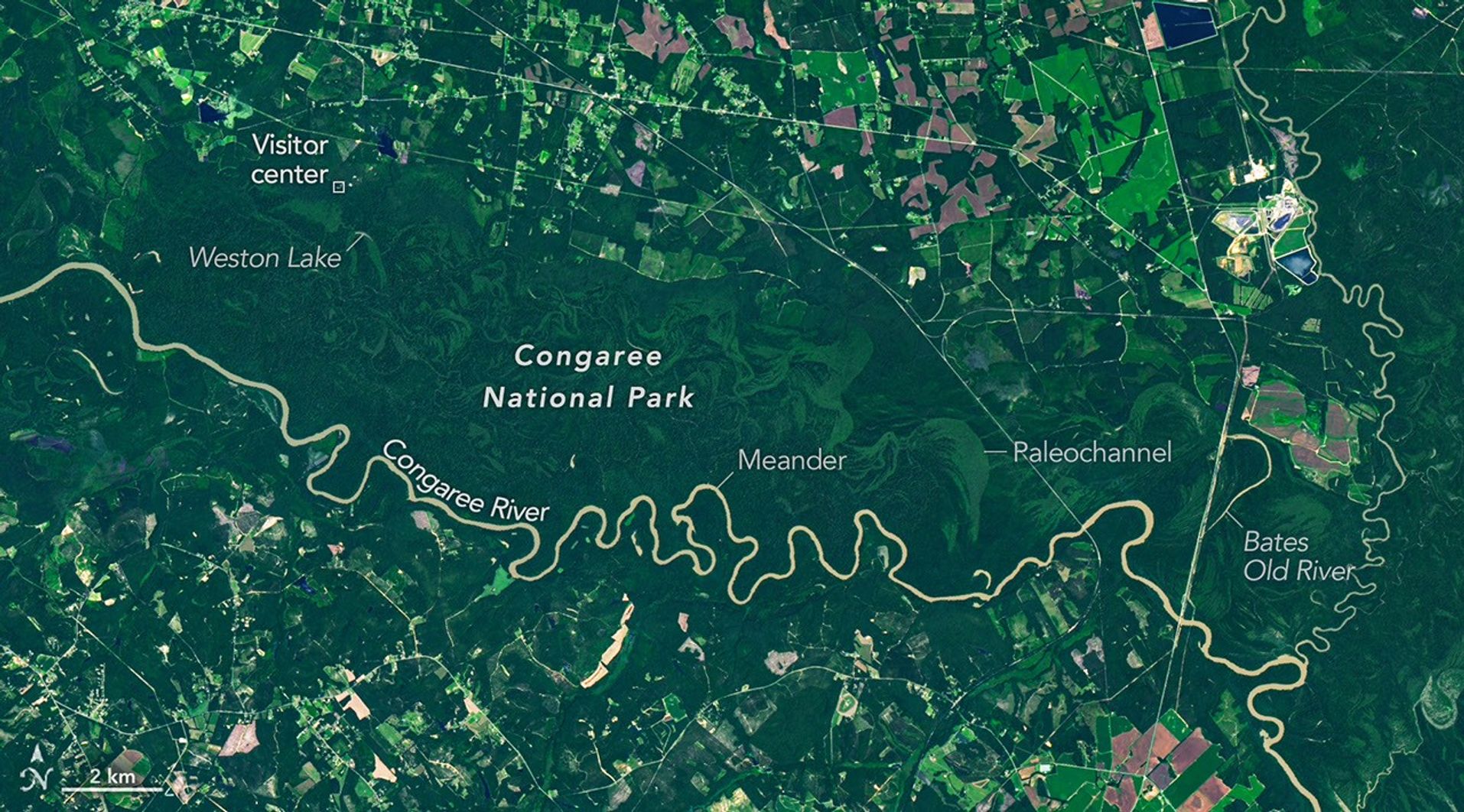
这里拥有美国境内最大的一片原始底层阔叶林。在这张由Landsat 9卫星上的OLI(陆地成像仪)拍摄的图像中,河流蜿蜒穿过森林平原,伴随着绿色的弯曲带,勾勒出河流在逐渐迁移过程中留下的古河道、山脊和洼地。这些古河道和其他地貌在海拔上的细微差异影响了它们的洪水频率,从而形成了在不同深浅绿色中呈现出的独特生态系统。
It's a place home to one of the largest intact tracts of old-growth bottomland hardwood forests in the United States. In this image captured by the OLI (Operational Land Imager) on Landsat 9, the river winds through the forested plain, along with curving bands of green that trace old channels, ridges, and swales left behind as the river gradually migrated across it. Slight differences in elevation in these paleochannels and other landforms affect how frequently they flood, producing distinct ecosystems that appear in contrasting shades of green.
河流流经平坦、松软的地形,这促进了河湾和曲流的形成。水流通常在河湾外侧流速较快,导致河道切割外侧河岸时侵蚀速度加快。而在河湾内侧,水流速度较慢,导致沉积物堆积,并生长出被称为点沙坝(point bars)的沙质地貌。随着时间的推移,这一过程可以将河湾从主河道中切断,形成U形的牛轭湖。
The river flows through flat, soft terrain, which encourages the formation of bends and meanders. Water typically flows faster on the outside of bends, leading to more rapid erosion as the channel carves into the outer riverbank. It moves more slowly on the inside of bends, resulting in the deposition of sediment and the growth of sandy features called point bars. Over time, this process can cut off a bend from the main river channel, forming U-shaped oxbow lakes.
美国国家公园管理局(National Park Service)将距离游客中心1.2英里(1.9公里)的韦斯顿湖(Weston Lake)列为公园内最稳定的牛轭湖之一,并指出它相对较深,且缺乏公园内大多数其他牛轭湖(如Devil's Elbow)中常见的浅层粘土和淤泥层。图像右侧是贝茨老河(Bates Old River),这是一条长约4英里的康加里河废弃河道,也是南卡罗来纳州最长的牛轭湖之一。随着时间的推移,废弃的河道和牛轭湖会被沉积物填满,变成浅水湿地。其中一些低洼的积水地貌被称为泥沼(sloughs),耐洪的柏树-塔普洛森林往往生长于此。
The National Park Service lists Weston Lake, 1.2 miles (1.9 kilometers) from the visitor center, as one of the park’s most permanent oxbow lakes, noting that it is relatively deep and lacks the shallow clay and silt layer found in most of the park's other oxbow lakes, such as Devil's Elbow. On the right side of the image is Bates Old River, a roughly 4-mile-long abandoned channel of the Congaree River and one of the longest oxbow lakes in South Carolina. Over time, abandoned channels and oxbow lakes can fill with sediment and become shallow wetlands. Some of these low-lying, water-filled features are known as sloughs, where flood-tolerant cypress-tupelo forests tend to grow.
虽然伐木工人在19世纪80年代曾盯上康加里沿岸的森林,但频繁的洪水、泥泞不堪的道路以及蚊虫肆虐等挑战,使得大部分洪泛区森林逃过了改变了东南部其他地区的广泛砍伐。到了20世纪50年代,环保人士开始意识到这种原始森林在该地区已变得多么稀有。国会于1976年将该地区指定为国家纪念地,并于2003年成为国家公园。
While loggers targeted forests along the Congaree in the 1880s, challenges such as frequent flooding, interminably muddy roads, and mosquito-plagued conditions meant that most of the floodplain forests escaped the widespread logging that transformed other parts of the Southeast. By the 1950s, conservationists had begun to recognize how rare old-growth forests of this type had become in the region. Congress designated the area a national monument in 1976, and it became a national park in 2003.
当河流蜿蜒穿过公园大部分平坦的地形时,它每年会多次漫过河岸,通常是在冬季和初春,但在飓风和强降雨过后的夏季和秋季也会发生。这些洪水将富含养分的淤泥层分布在整个洪泛区,滋养了森林,并促成了公园内异常高大的树木群。
As the river snakes its way through the park's mostly flat terrain, it overflows its banks several times per year, usually in the winter and early spring but also in the summer and fall after hurricanes and major rainstorms. These floods distribute broad layers of nutrient-rich silt throughout the floodplain, nourishing the forests and contributing to the high concentration of unusually large trees in the park.
几十年来,康加里国家公园孕育了一系列非凡的“冠军”巨树,它们在各自的物种中保持着国家和州级的尺寸记录。尽管一些树木因受损、死亡或被其他地方新测量的树木超越而失去了冠军地位,但康加里的一些树木,如冬青叶冬青(Ilex decidua)、水山核桃(Carya aquatica)、火炬松(Pinus taeda)、月桂栎(Quercus laurifolia)、双花紫树(Nyssa biflora)和枫香树(Liquidambar styraciflua)都曾一度保持过记录。
Over the decades, Congaree National Park has harbored a remarkable array of giant "champion" trees that have held national and state size records for their species. Though individual trees have gained and lost champion status as they have been damaged, have died, or been surpassed by newly measured trees elsewhere, Congaree trees such as the possumhaw (Ilex decidua), water hickory (Carya aquatica), loblolly pine (Pinus taeda), laurel oak (Quercus laurifolia), swamp tupelo (Nyssa biflora), and sweetgum (Liquidambar styraciflua) have held records at times.
在本次国家公园周期间,请通过探索地球天文台(Earth Observatory)的“太空视角下的美国国家公园”系列来庆祝。您还可以查看“地球到天空”(Earth to Sky)提供的资源,这是一个将美国国家航天局(NASA)科学与全国公园管理局护林员联系起来的合作项目。
During this National Park Week, celebrate by exploring Earth Observatory's U.S. National Parks from Space collection. You can also check out the offerings of Earth to Sky, a collaborative program that connects NASA science with park service rangers across the nation.
图注:NASA地球天文台图像由Michala Garrison制作,使用了美国地质调查局(U.S. Geological Survey)的Landsat数据。文章作者:Adam Voiland。
NASA Earth Observatory image by Michala Garrison, using Landsat data from the U.S. Geological Survey. Story by Adam Voiland.
参考文献与资源
References & Resources
American Forests (2009) Congaree: Where The Trees Are Still Tall. Accessed August 27, 2026.
- American Forests (2009) Congaree: Where The Trees Are Still Tall. Accessed August 27, 2026.
Atlas Obscura (2025, May 12) How One Biologist Drew a Hyper-Accurate, Ranger-Approved Map of Congaree National Park. Accessed August 27, 2026.
- Atlas Obscura (2025, May 12) How One Biologist Drew a Hyper-Accurate, Ranger-Approved Map of Congaree National Park. Accessed August 27, 2026.
Discover South Carolina, Champion Trees are Star Attraction at Congaree National Park. Accessed August 27, 2026.
- Discover South Carolina, Champion Trees are Star Attraction at Congaree National Park. Accessed August 27, 2026.
National Parks Conservation Association (2024, March 27) Congaree: 'Champion' Trees, Synchronous Fireflies and More. Accessed August 27, 2026.
- National Parks Conservation Association (2024, March 27) Congaree: 'Champion' Trees, Synchronous Fireflies and More. Accessed August 27, 2026.
National Parks Conservation Association (2017) The Wild Congaree. Accessed August 27, 2026.
- National Parks Conservation Association (2017) The Wild Congaree. Accessed August 27, 2026.
National Park Maps, Congaree Forest Map. Accessed August 27, 2026.
- National Park Maps, Congaree Forest Map. Accessed August 27, 2026.
National Park Service, Last Stand for Floodplain Forests. Accessed August 27, 2026.
- National Park Service, Last Stand for Floodplain Forests. Accessed August 27, 2026.
National Park Service, Congaree National Park. Accessed August 27, 2026.
- National Park Service, Congaree National Park. Accessed August 27, 2026.
National Park Service (2014) Congaree National Park: Geologic Resources Inventory Report. Accessed August 27, 2026.
- National Park Service (2014) Congaree National Park: Geologic Resources Inventory Report. Accessed August 27, 2026.
U.S. Environmental Protection Agency, Bottomland Hardwoods. Accessed August 27, 2026.
- U.S. Environmental Protection Agency, Bottomland Hardwoods. Accessed August 27, 2026.
U.S. Geological Survey Ecology of Congaree National Park. Accessed August 27, 2026.
- U.S. Geological Survey Ecology of Congaree National Park. Accessed August 27, 2026.
来源与许可
原文来自公共领域来源;译文由机器生成,请以原文为准。 原始页面