
查看原文全部插图(15 幅)






内容提要
2026年8月,智利北部的阿塔卡马沙漠遭遇了罕见的广泛降雪,部分地区甚至出现了强降雨。此次极端天气事件与厄尔尼诺现象背景下的切断低压系统有关,对当地基础设施造成了严重影响。
原文全文译文
2026年8月,接连不断的冬季风暴使智利北部的阿塔卡马沙漠部分地区覆盖上了一层罕见的积雪。这个通常干旱的地区此前也曾出现过降雪,特别是在2025年以及更早的2011年。但2026年的其中一次降雪范围异常广泛,从安第斯山脉一直延伸到靠近太平洋海岸的地区。
In August 2026, back-to-back winter storms left parts of the Atacama Desert in northern Chile covered in a rare blanket of snow. The typically arid region has seen snowfall before, notably in 2025 and before that in 2011. But one of the 2026 events was unusually widespread, stretching from the Andes to near the Pacific coast.
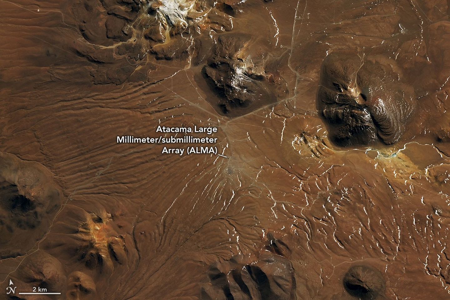
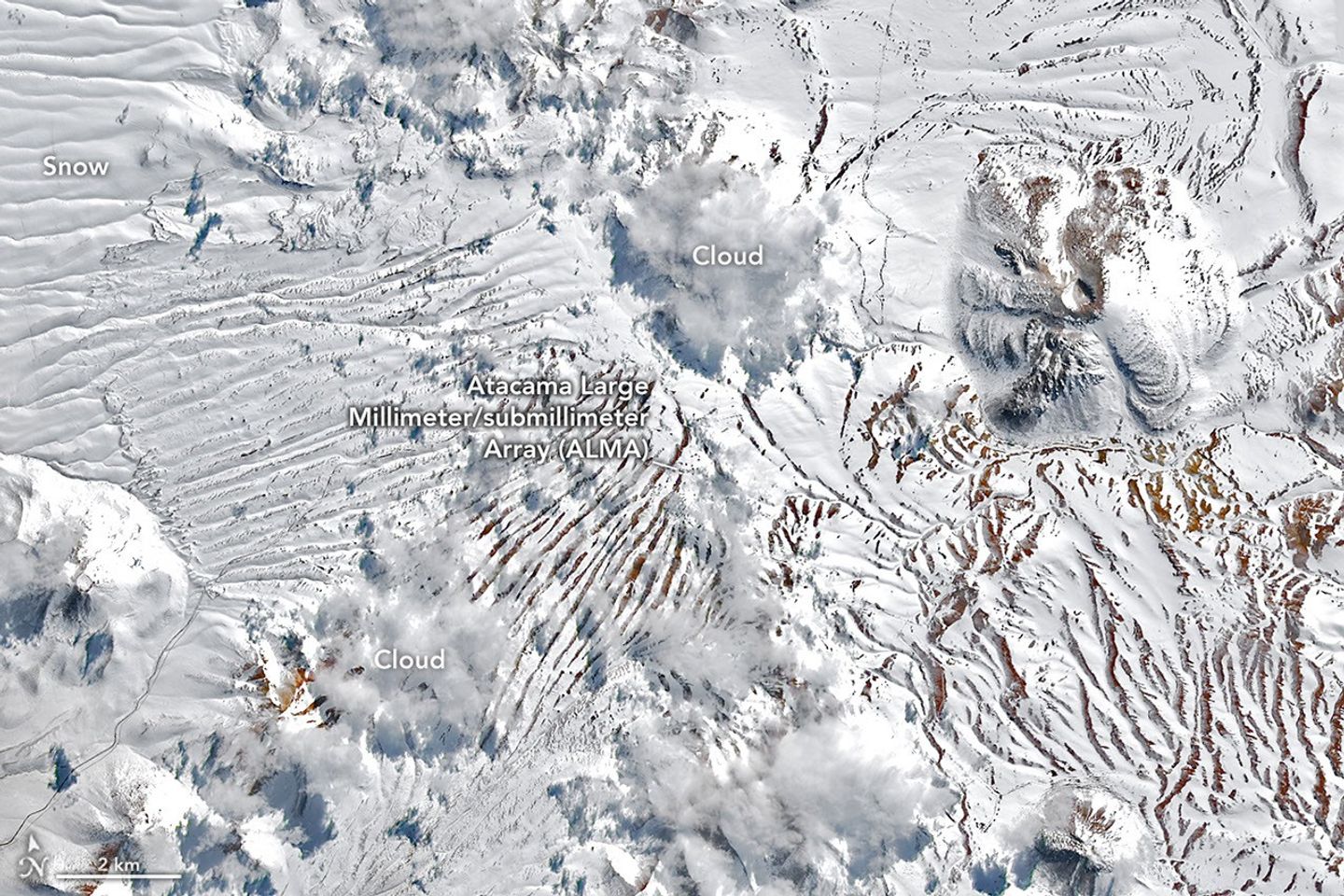
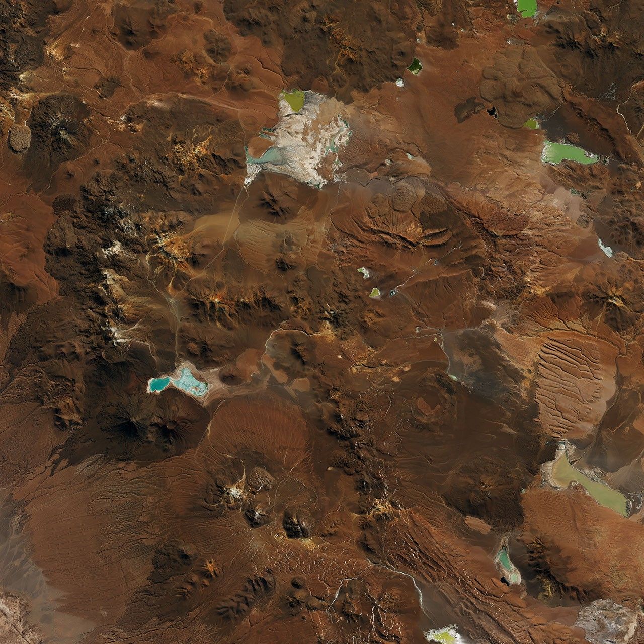
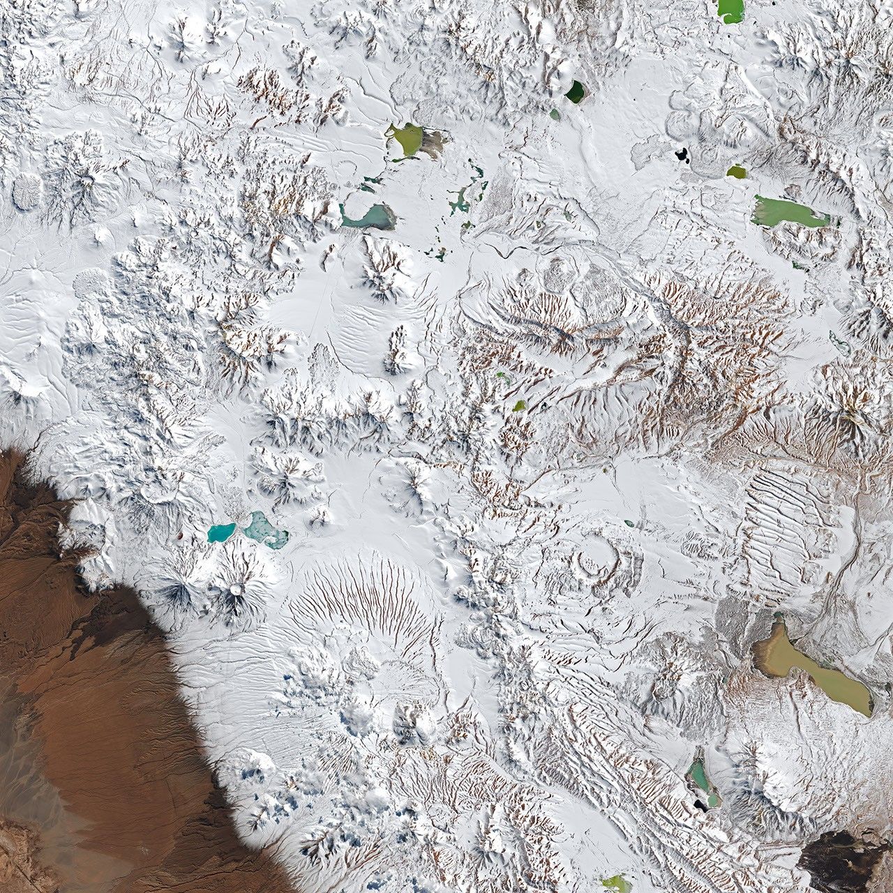
美国国家航天局(NASA)与美国地质调查局(USGS)Landsat 8和Landsat 9卫星上的陆地成像仪(OLI)分别在8月6日和8月14日,即恶劣天气发生的前后拍摄了这些图像(见上图)。它们详细展示了位于阿尔蒂普拉诺-普纳火山复合体内的查南托高原,这里坐落着阿塔卡马大型毫米/亚毫米波阵(ALMA)——这是地球上最强大的射电望远镜之一。随着降雪和强风来袭,ALMA暂停了观测,并将天线移动到保护性的生存模式。
The OLI (Operational Land Imager) on the NASA-USGS Landsat 8 and Landsat 9 satellites captured these images (above) on August 6 and August 14, before and after a period of severe weather, respectively. They show a detailed view of the Chajnantor plateau within the Altiplano-Puna volcanic complex, home to the Atacama Large Millimeter/submillimeter Array (ALMA)—one of the planet’s most powerful radio telescopes. As snow and high winds set in, ALMA suspended operations, moving its antennas into a protective survival mode.
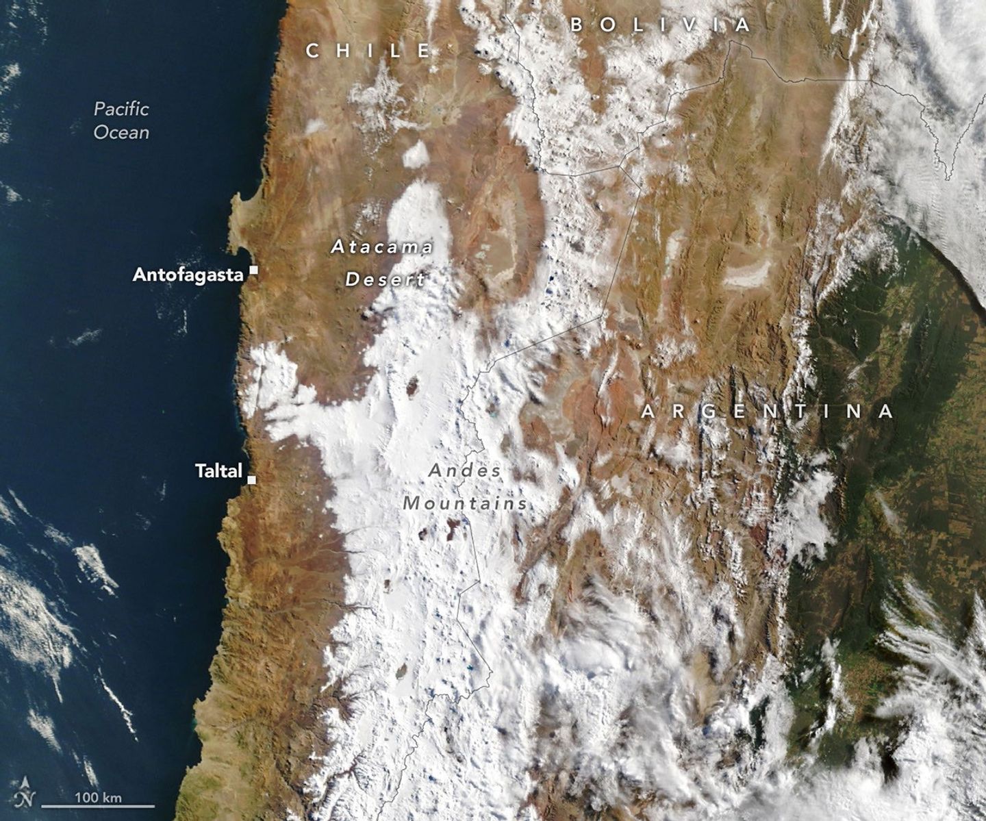
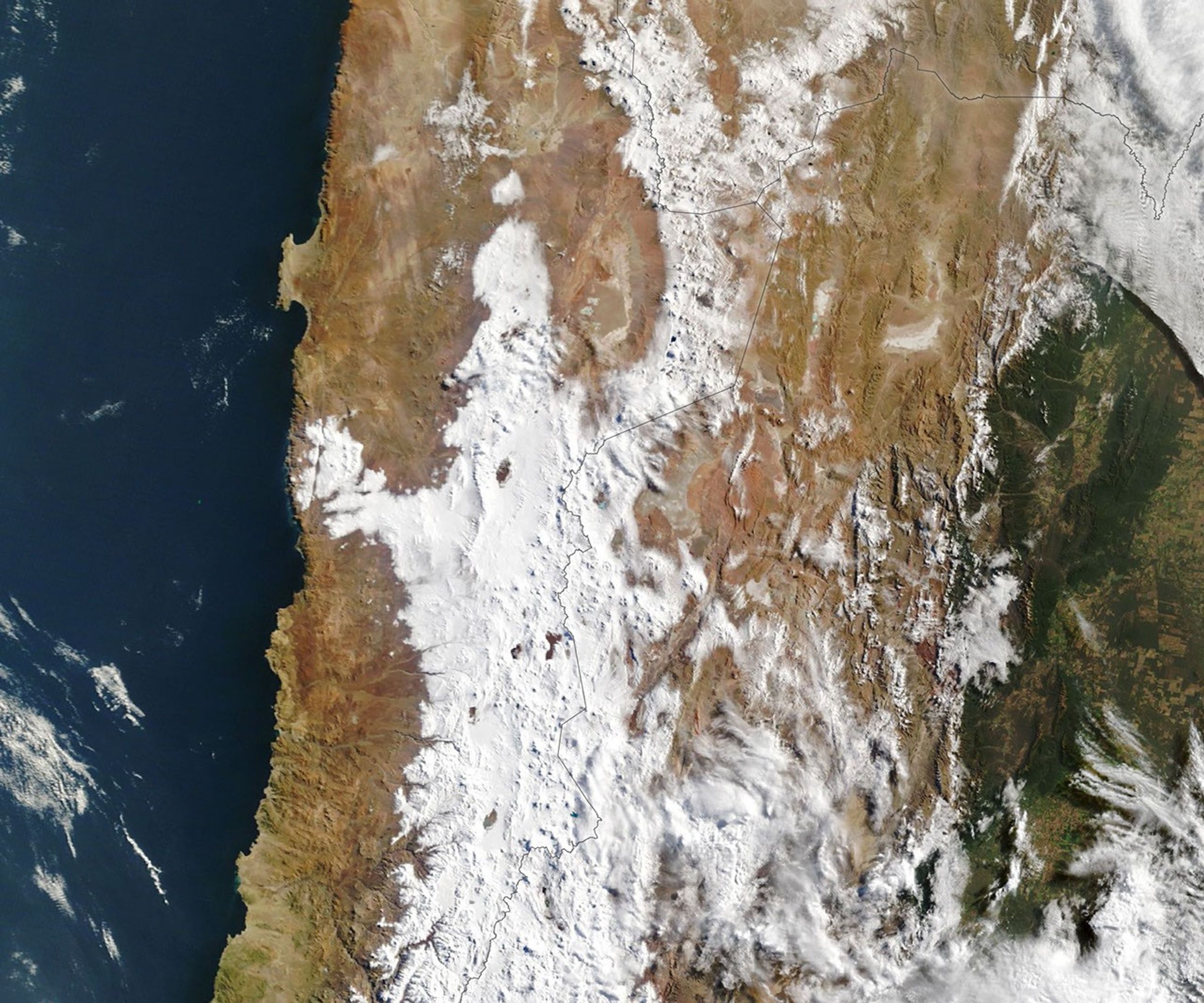
该月下半月的另一场风暴使更大范围的区域覆盖了新雪。这张由美国国家航天局Terra卫星上的中分辨率成像光谱仪(MODIS)于8月19日拍摄的图像显示,积雪从安第斯山脉向西延伸,穿过沙漠极度干旱的核心地带,并靠近智利港口城市安托法加斯塔以南的太平洋海岸。该沿海地区还分布着其他几座主要的天文台,其中一些也在事件期间暂停了观测。
Another storm in the second half of the month blanketed an even wider area with fresh snowfall. This image, captured by the MODIS (Moderate Resolution Imaging Spectroradiometer) on NASA's Terra satellite on August 19, shows snow extending westward from the Andes, across the desert’s hyper-arid core, and close to the Pacific coast south of the Chilean port city of Antofagasta. This coastal area is home to several other major astronomical observatories, some of which also suspended operations during the event.
该地区大部分的冬季降水来自切断低压——这是一种与急流脱离并偶尔能到达智利北部的低压系统。智利大学的大气科学家René Garreaud表示,2025年发生的情况正是如此。2026年8月下旬的风暴也源于一个切断低压,但这次是由一个异常巨大的槽(一种相对大气压较低的细长区域)分裂出来的,该槽横跨了从南美洲尖端一直到亚热带的巨大半球区域。
Most of the region’s winter precipitation comes from cutoff lows—low-pressure systems that become cut off from the jet stream and can occasionally reach northern Chile. That’s what happened in 2025, said René Garreaud, an atmospheric scientist at the University of Chile. The late-August 2026 storm also came from a cutoff low, but this one spun off from an unusually large trough—an elongated area of relatively low atmospheric pressure—that spanned an enormous stretch of the hemisphere, from the tip of South America up into the subtropics.
这种大气扰动结合充足的沿海湿气,产生的降水覆盖了该地区异常广阔的范围——包括近海、沿海、阿塔卡马核心地带以及安第斯山脉上空。Garreaud说,降水总量达到了“在这个极其干旱的地区罕见”的星等。
The atmospheric disruption, combined with ample coastal moisture, produced precipitation that spanned an unusually wide swath of the region—offshore, along the coast, across the core of the Atacama, and over the Andes. Totals reached a magnitude “rarely seen in the otherwise extremely arid region,” Garreaud said.
在某些地区,降水形式是雨而非雪。例如,在智利北海岸的塔尔塔尔,三天内累计降雨量近40毫米(1.6英寸),约为其年平均降雨量的10倍。Garreaud说:“我们每十年才会看到几次这样的事件,甚至可能更少。”
In some areas it fell as rain, not snow. Taltal, for instance, on Chile’s northern coast, accumulated nearly 40 millimeters (1.6 inches) of rain in three days—about 10 times its annual mean, Garreaud said. “We see these kinds of events only a few times, if any, per decade.”
充沛的降水在智利北部部分地区引发了破坏性的泥石流和山洪。国家灾害预防和响应服务局(SENAPRED)报告称,数千人受到影响,数百所房屋遭受严重破坏。
The abundant precipitation spurred destructive mudflows and flash flooding in parts of northern Chile. The National Disaster Prevention and Response Service (SENAPRED) reported thousands were affected and hundreds of homes had major damage.
Garreaud指出,厄尔尼诺现象的增强是智利中北部异常潮湿冬季的背景。除了8月的风暴外,7月发生的一次重大事件也对该国的北奇科地区造成了重大影响。在厄尔尼诺期间,通常使该地区保持干燥的副热带太平洋高压会减弱,而南太平洋靠近大陆尖端的地方往往会形成阻塞高压。这些变化共同将南半球的风暴路径推向赤道方向。
Garreaud noted that the strengthening El Niño is the backdrop for the anomalously wet winter in north-central Chile. In addition to the August storms, a major event in July brought significant impacts to the country’s Norte Chico region. During El Niño, the subtropical Pacific high—which normally keeps the region dry—weakens, while a blocking high tends to form in the South Pacific near the tip of the continent. Together, these shifts push the Southern Hemisphere storm track equatorward.
图注:美国国家航天局地球天文台图像由Lauren Dauphin制作,使用了美国地质调查局的Landsat数据以及美国国家航天局EOSDIS LANCE和GIBS/Worldview的MODIS数据。报道作者:Kathryn Hansen。
NASA Earth Observatory images by Lauren Dauphin, using Landsat data from the U.S. Geological Survey and MODIS data from NASA EOSDIS LANCE and GIBS/Worldview. Story by Kathryn Hansen.
参考文献与资源
References & Resources
- CR2 (2026, July 23) The extreme event of July 15-20, 2026, within the context of the developing El Niño. Accessed August 26, 2026.
- CR2 (2026, July 23) The extreme event of July 15-20, 2026, within the context of the developing El Niño. Accessed August 26, 2026.
- NASA Earth Observatory (2025, July 19) Rare Snowfall in the Atacama Desert. Accessed August 26, 2026.
- NASA Earth Observatory (2025, July 19) Rare Snowfall in the Atacama Desert. Accessed August 26, 2026.
- National Weather Service, Climate Prediction Center (2026, August 13) El Niño/Southern Oscillation (ENSO) Diagnostic Discussion. Accessed August 26, 2026.
- National Weather Service, Climate Prediction Center (2026, August 13) El Niño/Southern Oscillation (ENSO) Diagnostic Discussion. Accessed August 26, 2026.
- The Watchers (2026, August 18) Snow and 90 km/h (55 mph) winds suspend ALMA observations in the Atacama Desert, Chile. Accessed August 26, 2026.
- The Watchers (2026, August 18) Snow and 90 km/h (55 mph) winds suspend ALMA observations in the Atacama Desert, Chile. Accessed August 26, 2026.
来源与许可
原文来自公共领域来源;译文由机器生成,请以原文为准。 原始页面