
查看原文全部插图(16 幅)






内容提要
科学家们正在开展一项名为 INSPYRE 的美国国家航天局(NASA)任务,旨在研究野火产生的火积雨云(pyroCb)。这些云团能将烟雾和颗粒物注入高层大气,对地球的臭氧层和能量收支产生潜在影响。
原文全文译文
长期以来,科学家们已知火山可以将大量颗粒物喷射到平流层中。在过去的几十年里,人们逐渐认识到野火也会通过产生高耸且充满烟雾的火积雨云(pyroCb)来实现这一过程。
Scientists have long known that volcanoes can launch large quantities of particles into the stratosphere. In the past few decades, it has become clear that wildfires do this, too, by generating towering, smoke-infused pyrocumulonimbus (pyroCb) clouds.
规模最大的 pyroCb 是令人惊叹的天气现象,它们能产生巨大的雷暴云团,并引发闪电、冰雹和强降雨。越来越多的研究表明,pyroCb 还能通过将脉冲式的颗粒物和气体输送到平流层干燥且无云的区域,从而对高层大气产生巨大的影响。一旦进入平流层,烟雾就会广泛扩散并停留数月甚至数年,有时会环绕全球,并可能影响臭氧层和地球的能量收支。
The largest pyroCbs are stunning weather-making features that generate massive thunderheads capable of unleashing lightning, hail, and heavy rain. A growing body of research shows that pyroCbs can also leave an outsized imprint on the upper atmosphere by channeling pulses of particles and gases into the stratosphere's mostly dry, cloudless confines. Once there, smoke can spread widely and linger for months or years, sometimes circling the globe and likely influencing the ozone layer and Earth's energy budget.
为了理解这些神秘而危险的云团,一个由大气科学家组成的团队正在度过一个夏天,利用 NASA 的 ER-2 飞机、NSF/NCAR 的 GV 飞机以及一套基于卡车的传感器来追逐它们。该团队是 NASA 一项名为 INSPYRE(注入烟雾与火积雨云实验)任务的成员。2026 年 8 月 3 日,该团队完成了夏季首次采样飞行之一,当时 GV 飞机穿过了来自 Widemouth 2 火灾的高空烟雾脉冲,这是犹他州今年迄今为止最大的火灾之一。
Understanding these enigmatic and dangerous clouds is why a team of atmospheric scientists—part of a NASA mission called INSPYRE (INjected Smoke and PYRocumulonimbus Experiment)—is spending the summer chasing them with NASA's ER-2 aircraft, NSF/NCAR's GV, and a suite of truck-based sensors. The team completed one of its first sampling runs of the summer on August 3, 2026, when the GV flew through a high-altitude pulse of smoke from the Widemouth 2 fire, one of Utah's largest so far this year.
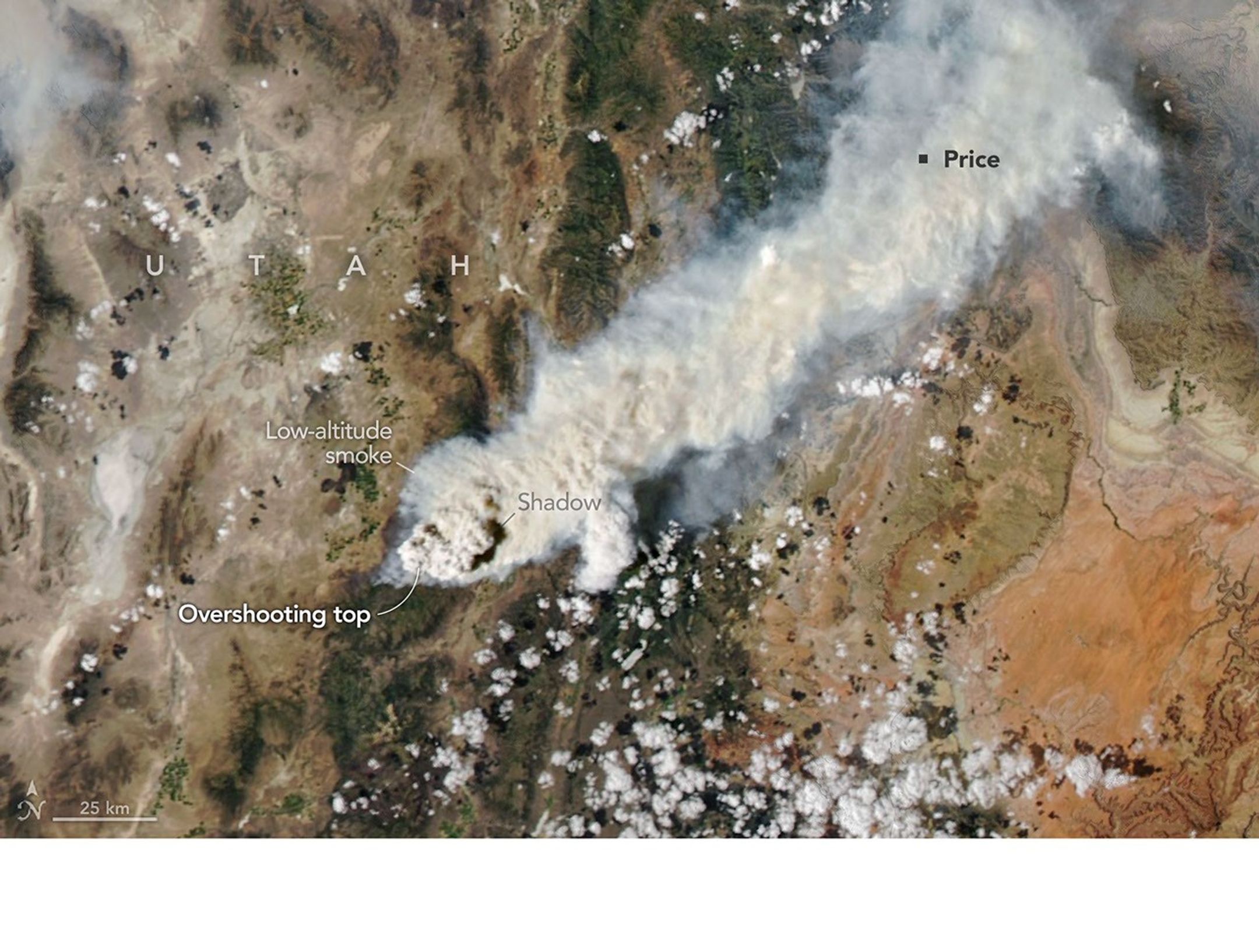
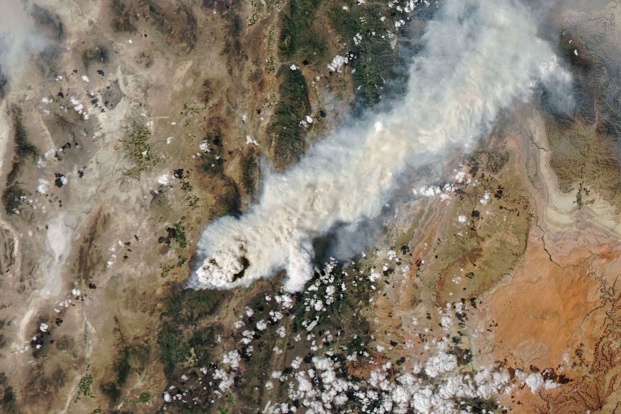
闪电于 2026 年 7 月 27 日引发了这场火灾,但在 8 月 2 日之前,火势相对较小。随着强风和高温干燥条件的出现,火势规模扩大了一倍多。那天下午,在产生两次 pyroCb 爆发后不久,NASA Aqua 卫星上的 MODIS(中分辨率成像光谱仪)捕捉到了这张图像(见上文),显示了一根高空云烟柱在下方低空烟雾上投下的阴影。
Lightning ignited the fire on July 27, 2026, but it remained relatively small until August 2, when it more than doubled in size amid intense winds and hot, dry conditions. That afternoon, soon after it had produced two pyroCb bursts, the MODIS (Moderate Resolution Imaging Spectroradiometer) on NASA's Aqua satellite captured this image (above), showing a chimney of high-altitude cloud and smoke casting a shadow on low-altitude smoke below.
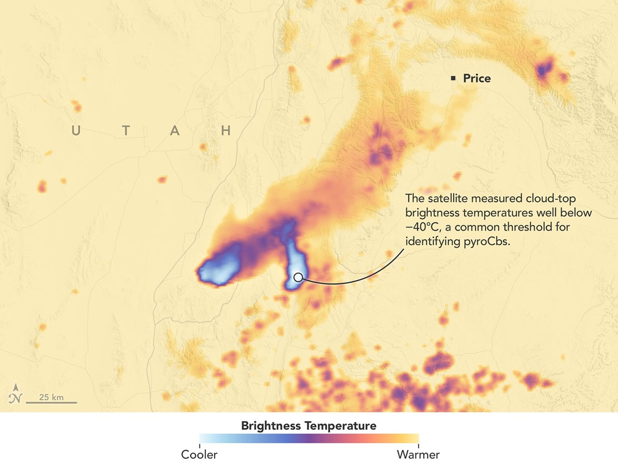
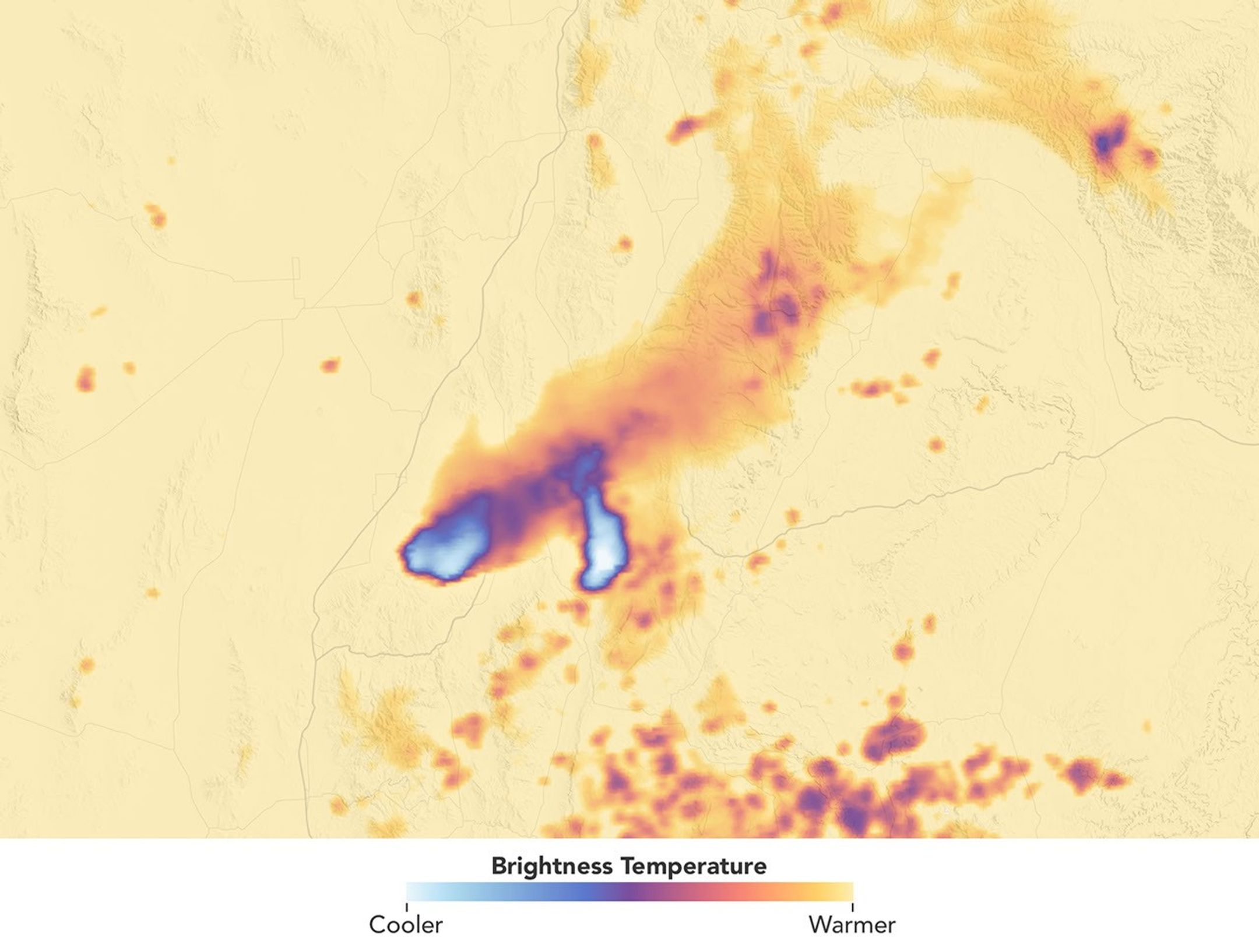
这些爆发将云团推向了足够高的高度,以至于 Aqua 测量到的云顶亮温度远低于 −40°C,这是识别 pyroCb 的常用阈值,也标志着云顶正在涌向对流层顶部,有时甚至进入平流层。美国海军科研实验室(Naval Research Laboratory)的科学家 Michael Fromm 表示,亮温度测量结果“揭示了两次离散的 pyroCb 活动脉冲”。“最西侧的是最新的一次脉冲,由于其阴影,在可见光图像中非常突出。”
These bursts propelled clouds high enough that Aqua measured cloud-top brightness temperatures well below −40°C, a common threshold for identifying pyroCbs and a sign that the cloud tops were bubbling to the top of the troposphere and sometimes into the stratosphere. The brightness temperature measurements "reveal two discrete pulses of pyroCb action," said Michael Fromm, a scientist at the U.S. Naval Research Laboratory. "The westernmost is the youngest pulse and stands out in the visible imagery by virtue of its shadow."
尽管这次 pyroCb 事件相对常规且规模较小,但它紧随同一场火灾在黎明前产生的另一个 pyroCb 之后,后者由美国国家海洋和大气管理局(NOAA)的气象卫星 GOES-West 拍摄到。Fromm 说:“早晨的 pyroCb 更为罕见”,因为它们无法受益于有助于促进对流的日间加热。然而在这种情况下,空气中似乎存在足够的大气不稳定性和水汽,从而允许了 pyroCb 的发展。
Though relatively routine and minor, this pyroCb event followed a pre-dawn pyroCb from the same fire, imaged by the NOAA weather satellite GOES-West. "Morning pyroCbs are much more unusual," Fromm said, because they don't benefit from daytime heating that helps fuel convection. In this case, however, there appeared to be enough atmospheric instability and water vapor in the air to allow for pyroCb development.
INSPYRE 的首席研究员 David Peterson 表示,一天内出现多次 pyroCb 可能会给正在扑灭火灾和组织疏散的预报员及消防官员增加不必要的复杂性。他补充说:“为火灾预报员最大限度地减少这种不确定性,是我们在这里研究它的重要原因。”
Multiple pyroCbs in a single day could have added unwanted complexity for forecasters and fire officials battling the blaze and organizing evacuations, said David Peterson, INSPYRE's principal investigator. "Minimizing that sort of uncertainty for fire forecasters is a big part of the reason we're out here studying this," he added.
像 Peterson 和 Fromm 这样的遥感专家通常会利用卫星从远处研究 pyroCb,但飞行员在烟羽形成后仅几小时就对其进行追逐和采样的情况并不常见。在这种情况下,当 Widemouth 2 火灾爆发时,正停在科罗拉多州地面的 GV 飞机在 8 月 3 日发现烟羽漂移到新墨西哥州上空时,便径直飞向了该高空烟羽。飞机上的仪器在距离地面约 12 公里(8 英里)的高度对烟雾进行了采样,收集了通常不会被纳入预报模型的数据。
Remote sensing experts like Peterson and Fromm routinely study pyroCbs from afar with satellites, but it's less common for pilots to chase and sample smoke plumes just hours after they form. In this case, the GV aircraft, on the ground in Colorado when the Widemouth 2 fire blew up, made a beeline for a high-altitude smoke plume as it drifted over New Mexico on August 3. The instruments on the plane sampled smoke at roughly 12 kilometers (8 miles) above the surface, collecting data at a height that isn't typically incorporated into forecast models.
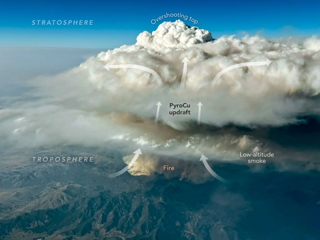
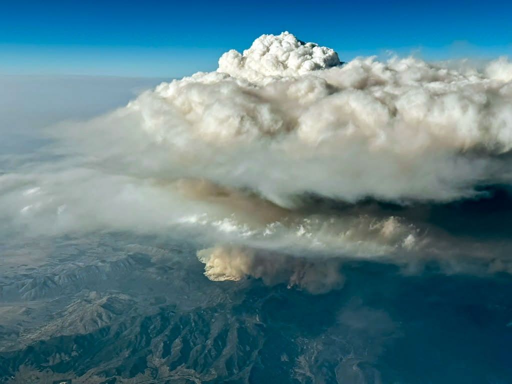
在执行该任务期间,机上的一位科学家捕捉到了这张(上文)火积云(pyroCu)在 Widemouth 2 火灾上方翻滚的图像。虽然火积云不像 pyroCb 那样高大或充满能量,但它们是具有许多相同特征的前体云。在这里,火灾产生的热量助长了强烈的对流上升气流,形成了一朵高耸的云,其蓬松的云顶冲入对流层上层,而低空烟雾则在下方漂移。
During that mission, a scientist on board captured this image (above) of a pyrocumulus (pyroCu) billowing up over the Widemouth 2 fire. While not as tall or energetic as pyroCbs, pyroCus are precursor clouds that share many of the same characteristics. Here, heat from the fire is fueling strong convective updrafts, forming a towering cloud with puffy overshooting tops that poke into the upper troposphere as lower-altitude smoke drifts below.
卫星通过测量烟羽上方形成的云顶温度,在识别 pyroCb 方面表现出色。利用这种技术,研究人员确定野火每年产生约 70 个 pyroCb,其中许多发生在加拿大和俄罗斯的茂密森林中,尽管在美国和澳大利亚的草原和稀树草原上也经常发生。2026 年迄今为止,Fromm 和同事们已在美国本土确定了至少 13 个。
Satellites excel at identifying pyroCbs by measuring the temperature of the cloud tops that form above smoke plumes. Using this technique, researchers have established that wildfires produce about 70 pyroCbs per year, many in dense forests of Canada and Russia, though plenty also occur in grasslands and savannas in the United States and Australia. So far in 2026, Fromm and colleagues have identified at least 13 in the continental United States.
自 21 世纪初科学文献中出现首批 pyroCb 以来,科学家们已经记录了 700 多起事件,他们现在认为野火可能贡献了平流层下层高达 25% 的黑碳和有机气溶胶。pyroCb 的高频出现意味着它们在一个火灾季节注入的颗粒物总质量可能与大型火山喷发相当。
Since one of the first pyroCbs appeared in the scientific literature in the early 2000s, scientists have cataloged well over 700 events, and they now believe that wildfires may contribute up to 25 percent of the black carbon and organic aerosols in the lower stratosphere. The sheer frequency of pyroCbs means that the total mass of particles they inject over the course of a wildfire season may rival that of large volcanic eruptions.
尽管如此,关于这些神秘云团的许多问题仍未得到解答。目前尚不清楚什么样的植被最容易助长 pyroCb,为什么有些云团产生的闪电比其他云团多,为什么它们只在极少数火灾中形成,以及如何准确地预报它们。
Still, many questions about the enigmatic clouds remain unanswered. It isn't clear what vegetation is most likely to fuel pyroCbs, why some form more lightning than others, why they form in only a small fraction of fires, and how to accurately forecast them.
Fromm 说:“无论是它们在地面上造成的危险表现,还是它们对对流层上层和平流层下层留下的持久印记,pyroCb 总是在不断给我们带来惊喜。”
"Whether it be their dangerous manifestations on the ground or their long-lasting imprint on the upper troposphere and lower stratosphere," Fromm said, "pyroCbs continue to surprise us."
图注:NASA 地球观测站(Earth Observatory)图像由 Michala Garrison 制作,使用了来自 NASA EOSDIS LANCE 和 GIBS/Worldview 的 MODIS 数据。照片由维也纳(Vienna)大学的 Bernadett Weinzierl 提供。文章作者:Adam Voiland。
NASA Earth Observatory images by Michala Garrison, using MODIS data from NASA EOSDIS LANCE and GIBS/Worldview. Photo by Bernadett Weinzierl/University of Vienna. Story by Adam Voiland.
References & Resources
- CIRA CSU, via Instagram (2026, August 3) Yesterday, the Widemouth 2 Fire in central Utah exploded. Accessed August 13, 2026.
- Denver 7, via Instagram (2026, July 28) Have you ever seen a smoke-filled cloud above a wildfire? Accessed August 13, 2026.
- The Economist (2026, August 9) NASA takes aim at fire storms. Accessed August 13, 2026.
- Fromm, M., et al. (2022) Understanding the critical elements of the pyrocumulonimbus storm sparked by high-intensity wildland fire. Communications Earth & Environment, 3, 243.
- InciWeb (2026) Widemouth 2 Fire. Accessed August 13, 2026.
- Katich, J.M. (2023) Pyrocumulonimbus affect average stratospheric aerosol composition. Science, 379(6634), 815-820.
- NASA (2026) INSPYRE. Accessed August 13, 2026.
- NASA Jet Propulsion Laboratory (2026, July 20) New NASA Earth Missions Gear Up to Start Science Flights. Accessed August 13, 2026.
- NASA Airborne Science Program (2026) Earth Science Observation Platforms. Accessed August 13, 2026.
- NASA Earth Observatory (2021, July 30) A Summer of Fire-Breathing Smoke Storms. Accessed August 13, 2026.
- NASA Earth Observatory (2020, January 10) Explosive Fire Activity in Australia. Accessed August 13, 2026.
- Peterson, D., et al. (2025) Worldwide inventory reveals the frequency and variability of pyrocumulonimbus and stratospheric smoke plumes during 2013–2023. Climate and Atmospheric Science, 8(325).
- The University of Utah (2026, August 6) Utah’s historic fire season of 2026. Accessed August 13, 2026.
- U.S. Naval Research Laboratory (2026, June 2) NRL Leads NASA Wildfire Research Mission to Better Predict Pyrocumulonimbus Storm Hazards. Accessed August 13, 2026.
- U.S. Naval Research Laboratory (2025, June 25) Fiery Storms: How Wildfires Create "Dirty Thunderstorms" and Impact Weather. Accessed August 13, 2026.
- The Weather Channel (2026, August 10) Meet the scientists who are flying into fire-breathing thunderstorms, and learn why they are doing it. Accessed August 13, 2026.
- Western Fire Chiefs (2026) Widemouth 2. Accessed August 13, 2026.
- World Meteorological Organization, Flammagenitus. Accessed August 13, 2026.
来源与许可
原文来自公共领域来源;译文由机器生成,请以原文为准。 原始页面